Tag: New
-

Leica iCON Introduces New ‘Roading’ Application and Major Productivity Gains with Updated iCONstruct v1.5 Field Software
Leica iCON Introduces New ‘Roading’ Application and Major Productivity Gains with Updated iCONstruct v1.5 Field Software Leica Geosystems has released a new, enhanced version of the iCONstruct field software for its pioneering Leica iCON portfolio of tailor-made positioning and measuring solutions for construction professionals. iCONstruct field v1.5 significantly improves and further optimizes construction workflow efficiency…
-

National Geodetic Survey (NGS) Online Map of Corbin’s New LiDAR Evaluation Site Available
Online Map of Corbin’s New LiDAR Evaluation Site Available In December, a permanent airborne Light Detection and Ranging (LiDAR) test and evaluation site was installed at the National Geodetic Survey (NGS) Instrumentation & Methodologies Branch facility located in Corbin, Virginia.
-

AutoCAD Civil 3D 911 Default Template File Name for QNEW
EMERGENCY AUTOCAD CIVIL 3D 911, HOW CAN WE HELP YOU? In this AutoCAD Civil 3D 911 series article is available to all site members beginning at the Associate Member level. Some names have been changed to protect the inquisitive. Submit your AutoCAD Civil 3D 911 request using the form at the end of this article. AutoCAD Civil 3D 911:…
-

Topcon Launches Three-Year ‘Bulletproof’ Warranty For GR-5
Topcon launches three-year ‘bulletproof’ warranty for GR-5 LIVERMORE, Calif. – Wednesday, August 29, 2012 Topcon Positioning Systems (TPS) is offering a three-year, guaranteed ‘bulletproof’ warranty for its industry-leading GR-5 high-precision GNSS receiver.
-
GEOID12 Error Analysis Complete and GEOID12A Model Developed
Here’s an important notice from The National Geodetic Survey (NGS) concerning the new GEOID12 model: The National Geodetic Survey has determined that the GEOID12 model was developed using erroneous input control points, primarily in the Gulf Coast region. NGS immediately corrected these errors and developed a replacement model: GEOID12A. GEOID12A is now available for public…
-

MAPPS Elects New Officers And Directors
MAPPS, the only national association of private sector geospatial firms, elected new members to its Board of Directors and a slate of officers to serve the association for 2012-2013. Jeff Lower, Vice President of Operations, Magnolia River Services, Inc. (Huntsville, AL) was elected to the position of President-Elect and will succeed to the office of…
-
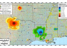
The National Geodetic Survey Improves the National Spatial Reference System with Simultaneous Major Product Releases
The National Geodetic Survey Improves the National Spatial Reference System with Simultaneous Major Product Releases In the first week of July, NOAA’s National Geodetic Survey (NGS) released the results of three major improvements to the National Spatial Reference System (NSRS). The NSRS is the consistent coordinate system that defines latitude, longitude, height, scale, gravity, and…
-

NGS Releases New Geoid Model to Serve Surveying, Engineering, and Scientific Communities
NGS Releases New Geoid Model to Serve Surveying, Engineering, and Scientific Communities In the last week, the National Geodetic Survey has released a new height transformation model for surveyors, engineers, and the scientific community involved in water flow and the determination of heights with respect to mean sea level. The new “GEOID12” model, implemented in…
-
Announcing New AutoCAD Civil 3D 911 Series
AutoCAD Civil 3D 911-Exploring, Discussing & Solving AutoCAD Civil 3D Problems Today, I’m announcing a new series of articles dedicated to solving your AutoCAD Civil 3D 911 problems. As a recurring feature, these AutoCAD Civil 3D 911 articles allow us to explore and discuss your routine, or unique, AutoCAD Civil 3D issues. AutoCAD Civil 3D 911 Series…
-
Trimble Introduces New Positioning Solution for Tunnel Construction
Integrated Office to Field Solution Makes Tunneling Safer, Faster and Less Expensive Trimble (NASDAQ:TRMB) today introduced a new positioning solution for tunneling contractors. The new solution leverages Business Center – HCE office software powered by Trimble, the Trimble® SCS900 Site Controller Software Tunneling Module operating on the Trimble Tablet, and the Trimble SPS930 Universal Total Station. As part…
-

Hemisphere GPS Introduces New miniEclipse™ Compact OEM Modules with GNSS Support
Hemisphere GPS Introduces New miniEclipse™ Compact OEM Modules with GNSS Support CALGARY, March 28, 2012 /CNW/ – (TSX: HEM) Today, Hemisphere GPS announces the Eclipse™ P300 and Eclipse P301 OEM modules – the next generation high-performance compact modules for RTK GNSS applications. Based on new Hemisphere GPS multi-function application firmware and Eclipse GNSS multi-constellation technology, P300 and P301 provide…
-

New Leica Digicat 600i and 650i For Safe and Fast Location of Underground Services
New Leica Digicat 600i and 650i for safe and fast location of underground services (Heerbrugg, 28th February 2012) – Leica Geosystems is delighted to announce the latest editions to their cable locator family, the Leica Digicat 600i and 650i series, accompanied with Logicat software, set to revolutionize underground cable location. Building on the success of previous models,…
-

Announcing New Land Surveying 911 Series for Professional and Business Solutions
Land Surveying 911-Exploring, Discussing & Solving Professional and Business Problems Today, I’m announcing a new series of articles dedicated to solving your Land Surveying 911 professional and business problems. As a recurring feature, these Land Surveying 911 articles allow us to explore and discuss your routine, or unique, professional land surveying issues. Land Surveying 911…
-

New Rugged Trimble Juno Series Puts GIS Field Work in Your Pocket
New Rugged Trimble Juno Series Puts GIS Field Work in Your Pocket SUNNYVALE, Calif., Feb. 8, 2012—Trimble (NASDAQ: TRMB) introduced today a new generation of GNSS devices for GIS field applications—the Trimble® Juno® 3B and 3D handhelds. With the new Trimble Juno series, mobile workforces ranging from public utilities to municipalities are empowered with rugged,…
-

Sokkia CX Total Station Series Sets New Standard for Performance and Security
Sokkia CX Total Station Series Sets New Standard for Performance and Security OLATHE, Kan. – January 16, 2012 – Sokkia announces a new industry standard for total station performance and security with the introduction of the CX total station series. Denny Welch, senior vice president-survey, said, “The CX series of total stations is not simply the…
-
New Century Software Releases Geometric Network Synchronizer
Operators using PODS gathering systems & complex transmission pipeline systems can now automatically keep multiple geometric networks synchronized Fort Collins, CO. January 11, 2011. New Century Software (http://www.newcenturysoftware.com) announces the release of its new product, Geometric Network Synchronizer. Geometric Network Synchronizer is both an Esri ArcMap extension and a server component that builds and maintains…
-

Professional Land Surveyor Weekly Roundup December 25, 2011
Professional Land Surveyor Weekly Roundup: Professional Land Surveyor Weekly Roundup December 25, 2011 Video Overview of AutoCAD Civil 3D CHC Introduces New Cost-Effective GNSS X900 Receiver Carlson Survey 2012 Embedded AutoCAD Now Available New Outlook Report Forecasts Rise in Investment in Equipment and Software in 2012 Professional Land Surveyor Weekly Roundup December 18, 2011 LightSquared…
-

CHC Introduces New Cost-Effective GNSS X900 Receiver
CHC introduces new cost-effective GNSS receiver : X900 Shanghai, China – (December 19th, 2011) – CHC today announced the availability of X900 GNSS receiver bringing extremely affordable and reliable GPS+GLONASS real-time centimeter level solution to surveyors without the conventional cost associated with GNSS solutions. The X900 GNSS combines field proven 72 channels GPS+GLONASS technology and…
-

New Outlook Report Forecasts Rise in Investment in Equipment and Software in 2012
New Outlook Report Forecasts Rise in Investment in Equipment and Software in 2012 Washington, DC, Dec. 19, 2011 –- The Equipment Leasing & Finance Foundation (the Foundation) launches its 2012 Equipment Leasing & Finance U.S. Economic Outlook today. The new report, which is focused on the $628 billion equipment finance sector, forecasts equipment investment and capital spending in the United States, and evaluates…