Category: Carlson

  • Professional Land Surveyor News: Carlson Machine Control Upgrades PDGrade™

    Carlson Machine Control’s New 3D Piling Machine Guidance System for Mixed Fleet Piling Applications Provides Greater Efficiency, Increased Safety and Lower Costs MAYSVILLE, Kentucky, U.S.A. (September 16, 2014)—  Carlson Machine Control has upgraded PDGrade™, an application-centric 3D positioning system for a variety of piling machines. First introduced in early 2013 and built on top of…

  • Carlson Software Upcoming Webinar: Fixing Corrupt AutoCAD Drawings and Using Civil 3D Files

    Join us for a Webinar on December 10!  Pick up practical skills this winter in this multifaceted two-in-one Webinar! Designed to help improve your everyday use of Carlson Software, this Webinar will be presented by Jennifer DiBona of That CAD Girl.  The first part will cover tips and tricks for recovering corrupted drawing files.  The…

  • Carlson Software Survey/Civil/Mining Training in Colorado, Dec. 16-19, 2013

    All new and/or basic CAD users are invited to attend any or all of these four full days of training in Carlson Survey (day 1), Carlson Civil (day 2) and Carlson Mining (days 3 & 4) in Denver, Colo., Dec. 16 through 19.  MAYSVILLE, Ky. (November 13, 2013) – Carlson Software is offering four days of…

  • Professional Surveyor Magazine Moving from Land Desktop to AutoCAD Civil 3D Software Review

    Last month’s Professional Surveyor Magazine included a Software Review: My Evolution from Land Desktop to Carlson Software by Jennifer DiBona, aka That CAD Girl. This was the first of a two-part series of articles explaining how and why two AutoCAD Land Desktop experts decided to move either to Carlson Software or AutoCAD Civil 3D. This month’s Professional Surveyor Magazine includes…

  • Carlson SurvCE 3.0 Data Collection Software Released

    Carlson Software Announces Newest SurvCE 3.0 Data Collection Software Update MAYSVILLE, Kentucky, U.S.A (May 2013) — At the opening session of the Carlson Software 30th Anniversary User Conference held recently in Cincinnati, Ohio, Bruce Carlson, president and founder of Carlson Software, announced that the newest version of Carlson Software’s popular data collection software – Carlson SurvCE 3.0…

  • Professional Surveyor Magazine Carlson Software Review

    In case you haven’t yet read your copy of Professional Surveyor Magazine this month, I want to let you know about a software review article of Carlson Software written by Jennifer DiBona. In the article, Jennifer describes her evolution from AutoCAD Land Desktop (LDT) to Carlson Software.

  • Hemisphere GPS and Carlson Software Establish Strategic Alliance

    Hemisphere GPS and Carlson Software Establish Strategic Alliance

    Hemisphere GPS and Carlson Software Establish Strategic Alliance SCOTTSDALE, AZ, Feb. 16, 2012 /CNW/ – (TSX: HEM) Today, Hemisphere GPS and Carlson Software announced a strategic alliance. This alliance will provide a roadmap for new, integrated solutions for land survey, mapping, construction, mining and other key machine control markets. Carlson Software is a leading developer of field…

  • Professional Land Surveyor Weekly Roundup January 29, 2012

    Professional Land Surveyor Weekly Roundup January 29, 2012

    Professional Land Surveyor Weekly Roundup: Create Survey Point Groups in AutoCAD Civil 3D Survey Databases Video NGS Developing GIS Tools and Datasets for Display and Analysis of Survey Data Carlson Software’s New Supervisor+GPS Tablet – aka The SuperG Video Professional Land Surveyor Weekly Roundup January 22, 2012 AutoCAD Civil 3D Set Survey Databases Working Folder…

  • Carlson Software’s New Supervisor+GPS Tablet – aka The SuperG Video

    Carlson Software’s New Supervisor+GPS Tablet – aka The SuperG Video

    Carlson Software introduces their new PC based tablet field computer, The Supervisor+GPS Tablet or SuperG. The SuperG has the option to add when purchased or upgraded later, an internal RTK GNSS receiver board, GPS+GLONASS. RTK corrections can be configured via internal GSM or CDMA radio or external UHF, 900mhz or other via BlueTooth or serial…

  • Professional Land Surveyor Weekly Roundup January 1, 2012

    Professional Land Surveyor Weekly Roundup January 1, 2012

    Professional Land Surveyor Weekly Roundup: ArcGIS Online Overview Video Video-Has The Land Surveying Industry Let You Down? Carlson Takeoff R5 Speeds Up Converting PDF Files & Much More Trimble’s Kirkland to Discuss LightSquared Issue in MAPPS Winter Meeting Keynote Address 4 Ingredients for a Successful Professional Land Surveyor Business Web Presence Professional Land Surveyor Survey-Has…

  • Carlson Takeoff R5 Speeds Up Converting PDF Files & Much More

    Carlson Takeoff R5 Speeds Up Converting PDF Files & Much More

    Carlson Takeoff R5 Speeds Up Converting PDF Files & Much More MAYSVILLE, Kentucky, U.S.A. — Carlson Takeoff R5, which comes with the AutoCAD® engine built-in, gives users increased 3D visualization, a whole new set of commands for working with PDF files, and the ability to produce customized, more professional reports among its many additional improvements. A…

  • Professional Land Surveyor Weekly Roundup December 25, 2011

    Professional Land Surveyor Weekly Roundup December 25, 2011

    Professional Land Surveyor Weekly Roundup: Professional Land Surveyor Weekly Roundup December 25, 2011 Video Overview of AutoCAD Civil 3D CHC Introduces New Cost-Effective GNSS X900 Receiver Carlson Survey 2012 Embedded AutoCAD Now Available New Outlook Report Forecasts Rise in Investment in Equipment and Software in 2012 Professional Land Surveyor Weekly Roundup December 18, 2011 LightSquared…

  • Carlson Survey 2012 Embedded AutoCAD Now Available

    Carlson Survey 2012 Embedded AutoCAD Now Available

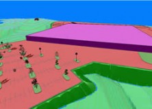
    Carlson Survey 2012 Embedded AutoCAD® Now Available MAYSVILLE, Kentucky, U.S.A. — Carlson Survey 2012 Embedded AutoCAD®, Carlson’s feature-rich, intuitive surveying office software with the AutoCAD engine built in, has just been released. Among the top improvements in the affordable Carlson Survey 2012 Embedded AutoCAD version is increased 3D visualization, new 3D coding in its industry-renowned field-to-finish,…

  • Professional Land Surveyor Weekly Roundup October 30, 2011

    Professional Land Surveyor Weekly Roundup October 30, 2011

    Professional Land Surveyor Weekly Roundup: Professional Land Surveyor Source Twitter Weekly Updates for 2011-10-30 Atlas Machinery Supply Ltd. Expands into the Construction Market with Leica Geosystems Canada Professional Land Surveyor Weekly Roundup October 23, 2011 Professional Land Surveyor Source Twitter Weekly Updates for 2011-10-23 NASA and Japan Release Improved Topographic Map of Earth Gatewing X100…

  • Carlson SurvCE Data Collection Software Now Available with Leica Viva CS10 and CS15

    Carlson SurvCE Data Collection Software Now Available with Leica Viva CS10 and CS15

    Carlson SurvCE Data Collection Software Now Available with the Leica Viva (Norcrosss, GA October 2011) All versions of Carlson SurvCE 2.56 and later now have updated drivers and feature sets available to work on the Leica CS10 and CS15, Field Controllers. “We think this will be a very popular combination,” says Bruce Carlson, president of…

  • Professional Land Surveyor Weekly Roundup September 18, 2011

    Professional Land Surveyor Weekly Roundup: Professional Land Surveyor Source Twitter Weekly Updates for 2011-09-18 USGS Historical Topographic Map Collection Now Online Sokkia Releases NET-AX Series of Automated Total Stations for 3D Monitoring LightSquared Video to Debunk Several GPS Interference Myths-Facts or Propaganda? Defense Department Seeks to Protect GPS Operations Against LightSquared Network House Aviation Subcommittee…

  • Just Released, Carlson Survey 2012 Provides Better 3D Visualization, New 3D Coding & More

    13 September 2011 MAYSVILLE, Ky., U.S.A. — Carlson Survey 2012, released in September 2011, gives users increased 3D visualization, extensive new 3D coding in its industry-renowned Field-to-Finish, and the ability to produce customized, more professional reports among its many additional improvements.

  • Virginia Tech Students Win First Place in the 14th Annual Carlson Software National Senior Design Competition

    Results of the 14th Annual Carlson Software National Senior Design Competition Are In Virginia Tech Students Take First Place MAYSVILLE, Ky., U.S.A. — Congratulations to all of the schools that participated in the 2011 Carlson Software National Senior Mine Design Competition.

  • Geo-Plus VisionPlus Voted 2011 Best Surveying Software for Professional Land Surveyors

    Geo-Plus, Providing Solutions for Land Management Professionals, Voted Best Surveying Software for Professional Land Surveyors for their Geo-Plus VisionPlus Land Surveying Software Geo-Plus VisionPlus has been voted the 2011 Best Surveying Software for Professional Land Surveyors on EricColburn.com with an impressive 45% of the votes. With over twenty-five entries in the Professional Land Surveyor Survey, the loyalty of Geo-Plus VisionPlus users…