Category: GPS
-

Leica Geosystems Announces Leica RCD30 Multi-Head Camera Concept
Leica Geosystems announces Leica RCD30 multi-head camera concept (Heerbrugg, 6 June 2012) – Leica Geosystems, the world’s leading manufacturer of airborne mapping solutions, announced today that it is expanding the very popular Leica RCD30 series of medium format cameras by adding dual-head and penta-head solutions to the portfolio. The Leica RCD30 combines unique design features such…
-

Esri GPS Base Station Joins National Continuously Operating Reference Station (CORS) Network
Real-Time, Precise Data Will Serve Professionals in the Redlands Community Redlands, California—Esri recently installed a GPS base station to assist its GIS developers and to support surveyors, engineers, scientists, and those in public works and public safety in the community surrounding the Esri campus in Redlands, California. The base station, named GISA, has been accepted…
-

Professional Land Surveyor Vlog 004-Survey Earth in a Day Interview
PLS Vlog 004-Survey Earth in a Day Interview In this Professional Land Surveyor Vlog I’m introducing a new format of Professional Land Surveyor Spotlight interviews. I hope you enjoy the interview and I will have more from time to time. In this inaugural Professional land Surveyor Spotlight, I interview Scott Warner, RLS, and VP Senior Director &…
-

Trimble Survey Software Improves Productivity for the Office and Field
Trimble’s Survey Software Improves Productivity for the Office and Field Trimble (NASDAQ:TRMB) introduced today new versions of its office and field surveying software—Trimble® Business Center Software version 2.70 and Trimble Access™ software version 2012.10. The software is part of Trimble’s portfolio of Connected Site® survey solutions. The new software enhancements allow surveyors to collect, share…
-
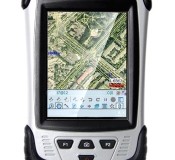
CHC Releases the LT30 GPS/GIS Handheld Collector
CHC Releases the LT30 GPS/GIS Handheld Collector Shanghai, China – (April 2nd, 2012) – CHC’s new LT30 series enters the GIS data collection market with a cost-effective, rugged and connected GPS/GIS handheld collector for a wide range of applications such as natural resources, forestry, utilities, agriculture, emergency response… Designed for real outdoor conditions, LT30 combines superb brightness…
-

Leica Geosystems Introduces The Latest Version 4.2 Of Its Leica Spider Software Suite For GNSS Networks and Reference Stations
Leica Geosystems introduces the latest version 4.2 of its Leica Spider Software Suite for GNSS Networks and Reference Stations Leica Geosystems is pleased to release the new version 4.2 of its market leading Leica Spider software suite. The globally used solution for GNSS RTK networks is being continually enhanced and developed following the market needs…
-

Trimble Acquires Gatewing to Expand its Survey Solutions to Include Aerial Mapping
Trimble Acquires Gatewing to Expand its Survey Solutions to Include Aerial Mapping SUNNYVALE, Calif., April 6, 2012—Trimble (NASDAQ:TRMB) announced today that it has acquired privately-held Gatewing of Gent, Belgium, a provider of lightweight unmanned aerial vehicles (UAV) for photogrammetry and rapid terrain mapping applications. The acquisition broadens Trimble’s industry-leading platforms for surveying solutions. Financial terms…
-
LightSquared Bankruptcy Now A Possible Option For Investor Phil Falcone
Phil Falcone, who invested around $3 billion in LightSqaured through his hedge fund Harbinger Capital Partners, is now considering placing the troubled broadband wireless company in bankruptcy.
-

Professional Land Surveyor Weekly Roundup March 4, 2012
Professional Land Surveyor Weekly Roundup: What Is The Major Challenge Facing Professional Land Surveyors Today? 3 Tools to Get Your Professional Land Surveying Business Paid Faster AutoCAD Civil 3D How To Insert Geo-Referenced Images Video New Leica Digicat 600i and 650i For Safe and Fast Location of Underground Services Professional Land Surveyor Weekly Roundup February…
-
Professional Land Surveyor Weekly Roundup February 26, 2012
Professional Land Surveyor Weekly Roundup: Topcon Introduces The PN-A5 GNSS Antenna AutoCAD Civil 3D How To Convert A 3D Polyline To A 2D Polyline Video Land Surveying 911: Which Land Surveyors Should I Layoff And Which Should I Keep? Professional Land Surveyor Weekly Roundup February 19, 2012 Hemisphere GPS and Carlson Software Establish Strategic Alliance…
-

Topcon Introduces The PN-A5 GNSS Antenna
Topcon introduces the PN-A5 GNSS antenna Innovative convex impedance ground plane, improved multipath mitigation LIVERMORE, Calif. – February 23, 2012 – Topcon Positioning Systems (TPS) announces the new PN-A5 GNSS antenna that combines the company’s TA-5 full spectrum GNSS antenna element with a newly designed semi-hemispherical convex impedance ground plane.
-

Professional Land Surveyor Weekly Roundup February 19, 2012
Professional Land Surveyor Weekly Roundup: Hemisphere GPS and Carlson Software Establish Strategic Alliance Announcing New Land Surveying 911 Series for Professional and Business Solutions Eric D. Colburn, PLS Now Offering Virtual Consultation Services With Easy Online Appointment Scheduling Extract AutoCAD Civil 3D Surface Border Video Topcon OS Total Station Series Introduces Multiple Technologies Description Keys…
-

Hemisphere GPS and Carlson Software Establish Strategic Alliance
Hemisphere GPS and Carlson Software Establish Strategic Alliance SCOTTSDALE, AZ, Feb. 16, 2012 /CNW/ – (TSX: HEM) Today, Hemisphere GPS and Carlson Software announced a strategic alliance. This alliance will provide a roadmap for new, integrated solutions for land survey, mapping, construction, mining and other key machine control markets. Carlson Software is a leading developer of field…
-

Professional Land Surveyor Weekly Roundup February 12, 2012
Professional Land Surveyor Weekly Roundup: Congress Told LightSquared Network Would Cripple GPS Air Traffic Navigation System William J. Beitler, PLS Named Pennsylvania Society of Land Surveyors’ (PSLS) Surveyor of the Year Topcon Precision Ag TV Spot Video New Rugged Trimble Juno Series Puts GIS Field Work in Your Pocket Autodesk Technology Makeover Contest for Small…
-

Congress Told LightSquared Network Would Cripple GPS Air Traffic Navigation System
THE SUBCOMMITTEE ON AVIATION HEARING EXAMINES GPS USE IN AVIATION INDUSTRY On Wednesday, February 8, The Subcommittee on Aviation held a hearing to review of issues associated with protecting and improving our nation’s aviation satellite-based global positioning system infrastructure. Here’s are interesting statements by the Honorable John Porcari, Deputy Secretary of the U.S. Department of Transportation: GPS…
-

Topcon Precision Ag TV Spot Video
Topcon Precision Ag TV Spot Topcon Precision AG Ad featured on US Farm Report — 8 Weeks, Feb. 11 and 18; Mar. 10 and 17; Apr. 7, 14, 21 and 28 – 30+ States on 150+ Stations To see where it plays in your area go to: http://www.agweb.com/usfr/stations
-

New Rugged Trimble Juno Series Puts GIS Field Work in Your Pocket
New Rugged Trimble Juno Series Puts GIS Field Work in Your Pocket SUNNYVALE, Calif., Feb. 8, 2012—Trimble (NASDAQ: TRMB) introduced today a new generation of GNSS devices for GIS field applications—the Trimble® Juno® 3B and 3D handhelds. With the new Trimble Juno series, mobile workforces ranging from public utilities to municipalities are empowered with rugged,…
-

Professional Land Surveyor Weekly Roundup February 5, 2012
Professional Land Surveyor Weekly Roundup: Professional Land Surveyor Weekly Roundup February 5, 2012 LightSquared Causes Falcone’s Harbinger Hedge Fund 47% Loss in 2011 Trimble MX8: Inside Look Video Create AutoCAD Civil 3D Parcels From Objects Video National Museum of Surveying: A Tour of the Only Museum of Its Kind Video Linkedin Poll: In 2012, What…
-
LightSquared Causes Falcone’s Harbinger Hedge Fund 47% Loss in 2011
Falcone’s Harbinger Hedge Fund Lost 47% in 2011
-

Trimble MX8: Inside Look Video
Trimble MX8: Inside Look Video An animated look inside the Trimble MX8 mobile spatial imaging system for mobile mapping and survey Watch The Video