Category: GPS
-

Surveyor’s Saturday Serendipity: How Satellites Work
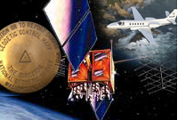
A wee bit of Surveyor’s Saturday Serendipity with this older, but interesting, video describes how satellites work: “Geostationary satellites are positioned one-tenth of the way to the moon (about 36,000 km), but how do they stay there? This video shows how satellites stay in orbit.” Watch the Surveyor’s Saturday Serendipity: How Satellites Work
-

Leica iCON Introduces New ‘Roading’ Application and Major Productivity Gains with Updated iCONstruct v1.5 Field Software
Leica iCON Introduces New ‘Roading’ Application and Major Productivity Gains with Updated iCONstruct v1.5 Field Software Leica Geosystems has released a new, enhanced version of the iCONstruct field software for its pioneering Leica iCON portfolio of tailor-made positioning and measuring solutions for construction professionals. iCONstruct field v1.5 significantly improves and further optimizes construction workflow efficiency…
-

National Surveyors Week – March 17-23, 2013 Announced By The National Society of Professional Surveyors (NSPS).
National Surveyors Week – March 17-23, 2013 National Surveyors Week will be celebrated nationwide March 17-23, according to the National Society of Professional Surveyors (NSPS). Hundreds of surveyors nationwide are planning activities, such as talks to school groups, contacts with their local news media about the importance of the nation’s surveying profession, booths at popular…
-

Agricultural Telematics Solution from Leica Geosystems
(Heerbrugg, Switzerland/Brisbane, Australia, 21 January 2013) – Today Leica Geosystems has launched Virtual VistaTM, a webbased platform which allows farmers to monitor their fleet and field activities in a simple and effective way. Virtual VistaTM connects directly through the built-in modem of the Leica mojo3D and customers can access the service within a few steps. No extra…
-

Trimble Acquires ALK Technologies to Extend its Transportation and Logistics Solutions to Shippers and Transportation Providers
SUNNYVALE, Calif., Jan. 3, 2013—Trimble (NASDAQ: TRMB) announced today that it has acquired privately-held ALK Technologies Inc. of Princeton, NJ, a global leader in routing, mapping, mileage and navigation technologies. ALK Technologies offers proprietary routing and international map-based solutions for transportation, logistics and mobile workforces. The addition of ALK® is expected to extend and complement…
-

Now available: Leica CS25 GNSS Tablet Computer with Integrated GNSS for Any Asset Collection & Management Task
Now available: Leica CS25 GNSS Tablet Computer with Integrated GNSS for Any Asset Collection & Management Task (Heerbrugg/Switzerland, 10 December 2012) – The Leica CS25 GNSS Tablet Computer packs full GNSS functionality into an ergonomic and portable device with a large screen, making it the industry’s most powerful GNSS/GIS handheld. The CS25 GNSS doesn’t require a…
-
National Geodetic Survey Updates “Bluebooking” Process for GPS Projects
NGS updates “Bluebooking” process for GPS projects. Breaking news from the NOAA National Geodetic Survey (NGS) about GPS projects “Bluebooking” process:
-

Google Maps Coordinate Workforce Management Tool
Google Maps Coordinate Helps The Right People Get The Right Jobs Done Faster! The above statement, taken from the below Youtube video’s description, highlights the potential of Google Maps Coordinate. I’ve investigated many work process, job management and scheduling software products, but by integrating location and real-time mapping into project management and scheduling, Google Maps…
-

NOAA Releases NGS Data Explorer Map Application
NOAA Releases NGS Data Explorer Map Application This week, NOAA released a new web application to allow users to view National Geodetic Survey (NGS) geodetic control across the United States and its territories using Google Maps.
-
Trimble Introduces Next Generation GNSS Surveying Solution
Trimble Introduces Next Generation GNSS Surveying Solution Trimble’s Powerful GNSS Receiver Provides Land Surveyors with Increased Productivity HANNOVER, Germany, Oct. 9, 2012—Trimble (NASDAQ: TRMB) introduced today its next generation GNSS surveying solution—the Trimble® R10. As the smallest and lightest receiver in its class, the Trimble R10 combines powerful features and groundbreaking technologies including Trimble HD-GNSS,…
-

Topcon IP-S2 Compact+ 3D Mobile Mapping System for a Wide Range of Applications
Topcon IP-S2 Compact+ 3D mobile mapping system for a wide range of applications LIVERMORE, Calif. – October 11, 2012 – Topcon Positioning System (TPS) introduces the new IP-S2 Compact+, an innovative mobile mapping system to accurately measure objects even in adverse weather conditions and enclosed job sites such as tunnels and mines.
-

Topcon Launches Three-Year ‘Bulletproof’ Warranty For GR-5
Topcon launches three-year ‘bulletproof’ warranty for GR-5 LIVERMORE, Calif. – Wednesday, August 29, 2012 Topcon Positioning Systems (TPS) is offering a three-year, guaranteed ‘bulletproof’ warranty for its industry-leading GR-5 high-precision GNSS receiver.
-

Topcon Launches TopNET Live Website
Topcon launches TopNET live website LIVERMORE, Calif. – Topcon Positioning Systems (TPS) announces the launch of the new TopNET live website. TopNET live is the new name for the restructuring of Topcon’s GNSS network business, and global GNSS services. The service offers subscription-based, real-time GNSS network RTK and DGPS subscriptions, with high quality GPS and…
-
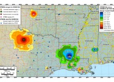
GEOID12 Error Analysis Complete and GEOID12A Model Developed
Here’s an important notice from The National Geodetic Survey (NGS) concerning the new GEOID12 model: The National Geodetic Survey has determined that the GEOID12 model was developed using erroneous input control points, primarily in the Gulf Coast region. NGS immediately corrected these errors and developed a replacement model: GEOID12A. GEOID12A is now available for public…
-

Leica Viva GS08plus – Lightest Cable-Free High-Accuracy GNSS System
Leica Viva GS08plus – Lightest cable-free high-accuracy GNSS system (Heerbrugg/Switzerland, 31 July 2012) – Leica Geosystems is pleased to announce a new GNSS solution to its successful Viva GNSS family. The Leica Viva GS08plus is the smallest and lightest cable-free high-accuracy GNSS system. Being light weight and ideally balanced, the Leica Viva GS08plus delivers ergonomic…
-

Professional Land Surveyor Weekly Roundup July 29, 2012
Professional Land Surveyor Weekly Roundup: Basic AutoCAD Civil 3D Setup Planning and Preparation How To Stop Avoiding Business And Professional Realities, Embrace Change, And Focus Your Goals Professional Land Surveyor Weekly Roundup July 22, 2012 The National Geodetic Survey Improves the National Spatial Reference System with Simultaneous Major Product Releases Earn a Degree in the…
-
The National Geodetic Survey Improves the National Spatial Reference System with Simultaneous Major Product Releases
The National Geodetic Survey Improves the National Spatial Reference System with Simultaneous Major Product Releases In the first week of July, NOAA’s National Geodetic Survey (NGS) released the results of three major improvements to the National Spatial Reference System (NSRS). The NSRS is the consistent coordinate system that defines latitude, longitude, height, scale, gravity, and…
-

NGS Releases New Geoid Model to Serve Surveying, Engineering, and Scientific Communities
NGS Releases New Geoid Model to Serve Surveying, Engineering, and Scientific Communities In the last week, the National Geodetic Survey has released a new height transformation model for surveyors, engineers, and the scientific community involved in water flow and the determination of heights with respect to mean sea level. The new “GEOID12” model, implemented in…
-

Drone GPS Spoofing Experiment
University of Texas at Austin GPS Spoofing experiment “GPS Spoofing experiment performed at the University of Texas at Austin by Dr Humphries. Actual GPS is changed to “confuse” the drone.” Source: Youtube Watch the Video