Tag: Topographic
-

NGS Enabling Historical “T-Sheets” to be Accurately and Efficiently Geo-referenced
NGS Enabling Historical “T-Sheets” to be Accurately and Efficiently Geo-referenced Historical Topographic Sheets (“T-Sheets”) produced by the U.S. Coast and Geodetic Survey are referenced to various horizontal datums in use over the two hundred years since the first Survey of the Coast in 1816. To use these maps to document coastal change, a conversion has…
-
The National Land Survey of Finland Opens Topographic Datasets 1 May 2012 For Free Use
The National Land Survey of Finland Opens Topographic Datasets 1 May 2012 For Free Use The Ministry for Agriculture and Forestry issued a decree on 21 December 2011 on the fees of the National Land Survey of Finland (NLS). The decree prescribes that the NLS will open its topographic datasets to the public on 1…
-

Maptek New Mid-range I-Site 8400 Laser Scanner Released
New Mid-range I-Site 8400 Laser Scanner Released Tuesday, November 29th, 2011 Mining technology specialist Maptek unveiled the new I-Site 8400 laser scanner at Intergeo in Germany at the end of September. Built at the Maptek I-Site manufacturing facility in Adelaide, South Australia, the I-Site 8400 has been launched following the international success of the long range I-Site 8800. The…
-

Professional Land Surveyor Weekly Roundup November 20, 2011
Professional Land Surveyor Weekly Roundup: Professional Land Surveyor Source Twitter Weekly Updates for 2011-11-20 Leica Viva GNSS Video Geographic and Land Information Society Board Votes to Continue GLIS as a Separate Organization Trimble Offers Custom Topographic, Aerial and Hybrid Map Prints Esri Press Book Presents Latest Crime Mapping and Analysis Methods NSPS and ACSM Action…
-

Trimble Offers Custom Topographic, Aerial and Hybrid Map Prints
Trimble Offers Custom Topographic, Aerial and Hybrid Map Prints
-

Professional Land Surveyor Weekly Roundup October 30, 2011
Professional Land Surveyor Weekly Roundup: Professional Land Surveyor Source Twitter Weekly Updates for 2011-10-30 Atlas Machinery Supply Ltd. Expands into the Construction Market with Leica Geosystems Canada Professional Land Surveyor Weekly Roundup October 23, 2011 Professional Land Surveyor Source Twitter Weekly Updates for 2011-10-23 NASA and Japan Release Improved Topographic Map of Earth Gatewing X100…
-

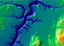
NASA and Japan Release Improved Topographic Map of Earth
PASADENA, Calif. – NASA and Japan released a significantly improved version of the most complete digital topographic map of Earth on Monday, produced with detailed measurements from NASA’s Terra spacecraft. The map, known as a global digital elevation model, was created from images collected by the Japanese Advanced Spaceborne Thermal Emission and Reflection Radiometer, or…
-

Gatewing X100 Product Video 2011
Here’s an informative video from Gatewing highlighting their Gatewing X100 product. About the Gatewing X100 From Gatewing: The X100 is the result of a thorough and multidisciplinary engineering process. It has been designed with two main goals in mind and with due consideration for the demanding field worker. It carries a camera payload, flies in…