Tag: Surface Border
-

AutoCAD Civil 3D Working With Images And Surfaces Professional Land Surveyor Learning Center Course
AutoCAD Civil 3D C3D-102 Working With Images And Surfaces Professional Land Surveyor Learning Center Course Now Available In this AutoCAD Civil 3D Professional Land Surveyor Learning Center (PLSLC) course, C3D-102 Working With Images And Surfaces, you will learn the best practices for working with Images and Surfaces when draping an Image over a Surface. What You Will…
-
Professional Land Surveyor Weekly Roundup March 11, 2012
Professional Land Surveyor Weekly Roundup: AutoCAD Civil 3D How To Trim Image to a Surface Border Video High-Definition Survey (HDS) Laser Scanning on Amtrak Video Land Surveying 911: Should I Pay For AutoCAD Civil 3D Training Or Try To Learn It On My Own? Professional Land Surveyor Weekly Roundup March 4, 2012 What Is The…
-

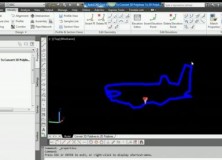
AutoCAD Civil 3D How To Trim Image to a Surface Border Video
AutoCAD Civil 3D How To Trim Image to a Surface Border This AutoCAD Civil 3D for Land Surveyors Video shows you how to trim an image, like a geo-referenced aerial photograph or orthophoto, to a Civil 3D Border.
-
AutoCAD Civil 3D How To Convert A 3D Polyline To A 2D Polyline Video
AutoCAD Civil 3D How To Convert A 3D Polyline To A 2D Polyline Video This AutoCAD Civil 3D for Land Surveyors Video shows you how to Convert a 3D Polyline to a 2D Polyline. Building on my last video, Extract AutoCAD Civil 3D Surface Border Video, I use the results of the steps shown in this…
-

Extract AutoCAD Civil 3D Surface Border Video
Extract An AutoCAD Civil 3D Surface Border To a 3D Polyline In this AutoCAD Civil 3D for Land Surveyors Video, you’ll learn how to extract an AutoCAD Civil 3D Surface Border.