Tag: Remote Sensing
-

DMK Associates Brings Leica ScanStation C5 Scanner to SW Florida
Regional leader DMK Associates Inc. chooses a Leica Geosystems ScanStation C5 scanner to equip Southwest Florida’s first permanently-based laser scanning crew. (Norcross, Ga./Heerbrugg, 2 July 2012) – DMK Associates, Inc., a 28-person full-service consulting firm serving counties and municipalities in Southwest Florida, recently established the region’s first dedicated laser scanning crew and chose the Leica ScanStation…
-

Integration of Laser Scanner Data & Mobile Mapping Data : Faro Focus 3D & Topcon IP-S2 Video
I’m just a sucker for a good laser scanning video, and here’s a new one. Watch the Integration of Laser Scanner Data & Mobile Mapping Data : Faro Focus 3D & Topcon IP-S2 Video
-

High-Definition Survey (HDS) Laser Scanning on Amtrak Video
High-Definition Survey (HDS) Laser Scanning on Amtrak Video “Chilton Engineering offers High-Definition Survey (HDS) laser scanning expertise on Amtrak corridor for City of Philadelphia Department of Streets bridge replacement project. Our efficient field survey delivered detailed data on catenary towers, horizontal and vertical track alignment, utilities, bridge cross-sections, abutments and more without disruption to rail…
-

UK Police Forces Embrace Leica Geosystems ScanStation C10 3D Laser Scanning
UK Police Forces Embrace Leica ScanStation C10 3D Laser Scanning 6 January 2012 (Milton Keynes, UK 5th January 2012) – Leica Geosystems is pleased to announce the largest ever order of Leica ScanStation C10’s as UK Police Forces embrace High Definition SurveyingTM (HDS). The scanners will be supplied as part of a £2.7 million investment from the Department…
-
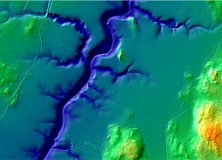
The National Land Survey of Finland Opens Topographic Datasets 1 May 2012 For Free Use
The National Land Survey of Finland Opens Topographic Datasets 1 May 2012 For Free Use The Ministry for Agriculture and Forestry issued a decree on 21 December 2011 on the fees of the National Land Survey of Finland (NLS). The decree prescribes that the NLS will open its topographic datasets to the public on 1…
-

GeoEye Wins Multi-year, Multi-million Dollar Russian Contract
GeoEye and ScanEx to Provide High-resolution Satellite Data for Russia’s Countrywide Cadastral Project HERNDON, Va., Jan. 4, 2012 /PRNewswire/ — GeoEye, Inc. (NASDAQ: GEOY), a leading source of geospatial information and insight, announced that it is working with its Russian partner, ScanEx Research and Development Center, to provide millions of square kilometers of high-resolution satellite…
-

Maptek New Mid-range I-Site 8400 Laser Scanner Released
New Mid-range I-Site 8400 Laser Scanner Released Tuesday, November 29th, 2011 Mining technology specialist Maptek unveiled the new I-Site 8400 laser scanner at Intergeo in Germany at the end of September. Built at the Maptek I-Site manufacturing facility in Adelaide, South Australia, the I-Site 8400 has been launched following the international success of the long range I-Site 8800. The…
-

Optech Announces Rapid Mobilization Platform for Lynx Mobile Mapper
Optech Announces Rapid Mobilization Platform for Lynx Mobile Mapper Toronto, Canada, September 27, 2011 Optech Incorporated, the world’s leading manufacturer of advanced lidar and camera survey instruments, is pleased to announce a new lightweight, state-of-the-art mounting platform for its Lynx Mobile Mapper. The newly designed rack features rigid mounting points and latching that virtually eliminate…
-
New Version of Topcon ScanMaster Software Improves Scanning Performance
New Version of Topcon ScanMaster Software Improves Scanning Performance LIVERMORE, Calif. – Thursday, October 27, 2011 Topcon Positioning Systems (TPS) has released a new version of software used with Topcon’s GLS series of laser scanners – ScanMaster v2.5. The new version was designed to improve existing features, add new functions, and broaden applications for scanning. “We’ve…
-

Gatewing X100 Product Video 2011
Here’s an informative video from Gatewing highlighting their Gatewing X100 product. About the Gatewing X100 From Gatewing: The X100 is the result of a thorough and multidisciplinary engineering process. It has been designed with two main goals in mind and with due consideration for the demanding field worker. It carries a camera payload, flies in…
-
Optech Announces New Airborne Laser Terrain Mappers (ALTM) Models: Orion M/C 300
Toronto, Canada, September 26, 2011 Optech Incorporated is pleased to announce the latest addition to its innovative line of airborne laser terrain mappers, the ALTM Orion M/C 300. Available in two models, the Orion M300 and C300 are specifically designed for mid-altitude engineering and low-altitude corridor applications respectively. Both models are now equipped with multipulse…