Tag: Points
-

AutoCAD Civil 3D Survey Field to Finish Webinar December 29, 2016
[NEW] AutoCAD Civil 3D Survey Field to Finish Webinar December 29, 2016 Register: Click Here When: December 29, 2016 1PM-4PM (EST) Where: Online (Watch Live or Recorded Webinar Later) Cost: Save $50 w/Early Bird Registation (until Dec. 10th), $297 Regular Price By: Eric Colburn, Professional Land Surveyor and Geo-Business Innovator AutoCAD Civil 3D Survey Field to Finish Webinar…
-

New AutoCAD Civil 3D Surveyor Training Course
This training course is for anyone who needs to know and understand how to use AutoCAD Civil 3D for land surveying / geomatics. If you’re switching over from AutoCAD Land Desktop, or just struggling with Civil 3D, then this is the course for you. This course is sent directly to your inbox so you can…
-

AutoCAD Civil 3D 911 Edit Multiple Points
EMERGENCY AUTOCAD CIVIL 3D 911, HOW CAN WE HELP YOU? In this AutoCAD Civil 3D 911 series article is available to all site members beginning at the Associate Member level. Some names have been changed to protect the inquisitive. Submit your AutoCAD Civil 3D 911 request using the form at the end of this article. AutoCAD Civil 3D 911:…
-
AutoCAD Civil 3D 2013 Service Pack 1
AutoCAD Civil 3D 2013 Service Pack 1 From Autodesk: In a continuing effort to provide high quality products, Autodesk has released AutoCAD Civil 3D 2013 Service Pack 1, which fixes or addresses a variety of issues discovered by customers and by Autodesk’s internal testing team. This Service Pack includes all previous hotfixes for AutoCAD Civil…
-
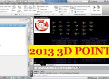
2013 AutoCAD Civil 3D Survey 3D Points Starter Template
I created the 2013 AutoCAD Civil 3D Survey 3D Points Starter Template(s) as a jumping-off point for land surveyors, or anyone using points in AutoCAD Civil 3D, to build their own custom template. The benefits of building from this template are many – saving you many hours of setup and frustrations – but here are…
-

Beginners AutoCAD Civil 3D Setup for Land Surveyors: Setup Drawing Settings
This Premium Members Post is part of a the Beginners AutoCAD Civil 3D Setup for Land Surveyors series. Today, let’s look at a few of the basic AutoCAD Civil 3D Drawing Settings to setup. There are five important settings that every land surveyor and designer must know how to set. These instructional articles are for Premium Members Only. You can…
-
Emergency AutoCAD Civil 3D 911: Point Inverse Video
EMERGENCY AUTOCAD CIVIL 3D 911, HOW CAN WE HELP YOU? In this AutoCAD Civil 3D 911 series article is available to all site members beginning at the (free) Associate Member level. Some names have been changed to protect the inquisitive. Submit your AutoCAD Civil 3D 911 request using the form at the end of this article. AutoCAD Civil…
-

Basic AutoCAD Civil 3D Setup Planning and Preparation
This Premium Members Post is part of a the Beginners AutoCAD Civil 3D Setup for Land Surveyors series. Today, let’s begin the real work in the Beginners AutoCAD Civil 3D Setup for Land Surveyors series with some preliminary planning and preparation. While this may not sound sexy, too many land surveyors and designers overlook or skip this step, resulting…
-

Intro to Beginners AutoCAD Civil 3D Setup for Land Surveyors
I get many request to write about how to set up AutoCAD Civil 3D for land surveyors. This Premium Members Post is an introduction to a series of articles for setting up AutoCAD Civil 3D for land surveying. If you’re struggling with setting up AutoCAD Civil 3D or you feel that you’re missing some key…
-

AutoCAD Civil 3D 2012 Update 2
Autodesk has released Update 2 for AutoCAD Civil 3D 2012: In a continuing effort to provide high quality products, Autodesk has released AutoCAD Civil 3D 2012 Service Pack 2, which fixes or addresses a variety of issues discovered by customers and by Autodesk’s internal testing team. This Service Pack includes all previous hotfixes and service…