Your cart is currently empty!
Tag: National Geodetic Survey
Precision and Accuracy in Geodetic Surveying Video by NOAA’s National Geodetic Survey and The COMET Program
This brief video, produced in collaboration between NOAA’s National Geodetic Survey and The COMET Program, is aimed at surveying professionals, planners, policy-makers and others who use mapping products. The video emphasizes that survey measurements need to be precise as well as verified as accurate by relating measurements to a known reference system such as the…

National Geodetic Survey (NGS) Online Map of Corbin’s New LiDAR Evaluation Site Available
Online Map of Corbin’s New LiDAR Evaluation Site Available In December, a permanent airborne Light Detection and Ranging (LiDAR) test and evaluation site was installed at the National Geodetic Survey (NGS) Instrumentation & Methodologies Branch facility located in Corbin, Virginia.

National Geodetic Survey Updates “Bluebooking” Process for GPS Projects
NGS updates “Bluebooking” process for GPS projects. Breaking news from the NOAA National Geodetic Survey (NGS) about GPS projects “Bluebooking” process:

NOAA Releases NGS Data Explorer Map Application
NOAA Releases NGS Data Explorer Map Application This week, NOAA released a new web application to allow users to view National Geodetic Survey (NGS) geodetic control across the United States and its territories using Google Maps.

NGS Enabling Historical “T-Sheets” to be Accurately and Efficiently Geo-referenced
NGS Enabling Historical “T-Sheets” to be Accurately and Efficiently Geo-referenced Historical Topographic Sheets (“T-Sheets”) produced by the U.S. Coast and Geodetic Survey are referenced to various horizontal datums in use over the two hundred years since the first Survey of the Coast in 1816. To use these maps to document coastal change, a conversion has…

GEOID12 Error Analysis Complete and GEOID12A Model Developed
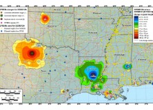
Here’s an important notice from The National Geodetic Survey (NGS) concerning the new GEOID12 model: The National Geodetic Survey has determined that the GEOID12 model was developed using erroneous input control points, primarily in the Gulf Coast region. NGS immediately corrected these errors and developed a replacement model: GEOID12A. GEOID12A is now available for public…

The National Geodetic Survey Improves the National Spatial Reference System with Simultaneous Major Product Releases
The National Geodetic Survey Improves the National Spatial Reference System with Simultaneous Major Product Releases In the first week of July, NOAA’s National Geodetic Survey (NGS) released the results of three major improvements to the National Spatial Reference System (NSRS). The NSRS is the consistent coordinate system that defines latitude, longitude, height, scale, gravity, and…

NGS Releases New Geoid Model to Serve Surveying, Engineering, and Scientific Communities
NGS Releases New Geoid Model to Serve Surveying, Engineering, and Scientific Communities In the last week, the National Geodetic Survey has released a new height transformation model for surveyors, engineers, and the scientific community involved in water flow and the determination of heights with respect to mean sea level. The new “GEOID12” model, implemented in…

Esri GPS Base Station Joins National Continuously Operating Reference Station (CORS) Network
Real-Time, Precise Data Will Serve Professionals in the Redlands Community Redlands, California—Esri recently installed a GPS base station to assist its GIS developers and to support surveyors, engineers, scientists, and those in public works and public safety in the community surrounding the Esri campus in Redlands, California. The base station, named GISA, has been accepted…

NGS Developing GIS Tools and Datasets for Display and Analysis of Survey Data
NGS Developing GIS Tools and Datasets for Display and Analysis of Survey Data NOAA’s National Geodetic Survey (NGS) is in the process of developing new Geographic Information System (GIS) software tools for display and analysis of NGS survey data.

Professional Land Surveyor Weekly Roundup October 9, 2011
Professional Land Surveyor Weekly Roundup: Professional Land Surveyor Source Twitter Weekly Updates for 2011-10-09 Knowing Your Numbers-Project Metrics for Your Land Surveying Company LightSquared CEO on The Communicators Senator Chuck Grassley Continues to Pursue Information on LightSquared, Agency Interaction Elgin & Knowles-The U.S. Public Land Survey System (PLSS) for Arkansas Reference Book and Manual New…

National Geodetic Survey (NGS) New CORS Coordinates and Absolute Antenna Calibration Pages
National Geodetic Survey (NGS) Releases New CORS Coordinates and Absolute Antenna Calibration Pages NAD83(2011,MA11,PA11) epoch 2010.00 Coordinates On September 6, 2011, NGS updated the National Spatial Reference System NAD 83 (CORS96, MARP00, PACP00) positions and velocities for all CORS sites, to NAD 83 (2011, MA11, PA11). The NAD 83 (2011) frame, which is relative to the…
NOAA’s VDatum a Free Unlimited Access Web-Based GIS Software Tool
NOAA Vertical Datum Transformation tool NOAA’s just-completed first edition VDatum tool will allow users to combine and transform geospatial data from different sources onto a single vertical reference surface, removing the largest obstacle GIS users face when creating products that enable safe navigation and serve other vital purposes for coastal communities. The Vertical Datum Transformation tool, known…
OPUS-Projects Manager Training
PUS-Projects Manager Training July 11-12, 2011 NGS is currently beta-testing a Network Processing Option for OPUS known as OPUS-Projects. This feature will allow the processing, adjustment and publishing of multiple stations over multiple days. Because of the increased complexity of this capability, the creation and management of Projects for OPUS is limited to those who have…
OPUS Soon To Have A New Look
Yesterday, I was using the National Geodetic Survey’s (NGS) Online Positioning User Service (OPUS), where there was a bright green notice at the top of the OPUS page that said, “OPUS will feature a new look-and-feel on or about 03/01/2011”. In researching this impending change to the look of OPUS, I found the following notice on…
National Geodetic Survey (NGS) Will Cease Accepting Traditional Triangulation and Traverse Geodetic Surveys
GPS is Taking over the World! The National Geodetic Survey (NGS) has announced a new policy that traditional horizontal survey projects performed with terrestrial survey techniques will no longer be accepted for processing or loading into NGS databases. The Specifics Are:
Video of Height Modernization Survey of Missouri Ceremony at the MO State Fair
Here’s a video and some links about the Height Modernization Survey of Missouri. From portions of the Missouri Department of Natural Resources Press Release (see link below): “ROLLA, MO, AUG. 27, 2010 – Professional land surveyors representing private firms from across the state contributed approximately $150,000 of professional services to the citizens of Missouri when they…
Professional Land Surveyor News: NOAA Releases Real-Time RTK Guidelines
Professional Land Surveyor News: NOAA Releases Real-Time RTK Guidelines This is a press release published by NOAA’s National Geodetic Survey (NGS) with important information for professional land surveyors who are using Real-Time GNSS positioning. NOAA’s National Geodetic Survey (NGS) recently announced the approval and release of a document titled “National Geodetic Survey User Guidelines for…
Professional Land Surveyor Newsletter Update
Just a quick note about the Professional Land Surveyor Newsletters. If you already subscribe you no doubt have noticed that I’ve added a few new features to these weekly newsletters, which I hope helps you to broaden your knowledge of other professionals and specifically helps you to navigate the social media sites making a few…
NOS Participates In International Geodesy Meeting In Argentina
From August 29 to September 5, representatives from NOAA’s National Geodetic Survey (NGS) participated in the International Association of Geodesy (IAG) meeting in Buenos Aires, Argentina. NGS presentations addressed many issues in geodesy and spatial coordinate reference systems. The meeting also presented an opportunity to highlight NGS’s new Gravity for the Redefinition of the American…