Your cart is currently empty!
Tag: NASA
-

NASA and Autodesk Collaborate on Sustainable Building Performance Monitoring
New Agreement to Advance Development of Technology to Monitor and Visualize Building Performance using Building Information Models
-

The U.S. Geological Survey (USGS) Releases New Heights of Accuracy for World Topography
The U.S. Geological Survey (USGS) and the National Geospatial-Intelligence Agency (NGA) have collaborated in the development of a much improved global elevation model, the Global Multi-resolution Terrain Elevation Data 2010 (GMTED2010). GMTED2010 replaces the widely used, 15-year-old GTOPO30 terrain model as the best available global digital elevation model. Useful for regional-, continental-, and global-scale applications,…
-
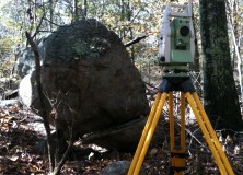
Professional Land Surveyor Weekly Roundup October 30, 2011
Professional Land Surveyor Weekly Roundup: Professional Land Surveyor Source Twitter Weekly Updates for 2011-10-30 Atlas Machinery Supply Ltd. Expands into the Construction Market with Leica Geosystems Canada Professional Land Surveyor Weekly Roundup October 23, 2011 Professional Land Surveyor Source Twitter Weekly Updates for 2011-10-23 NASA and Japan Release Improved Topographic Map of Earth Gatewing X100…
-

NASA and Japan Release Improved Topographic Map of Earth
PASADENA, Calif. – NASA and Japan released a significantly improved version of the most complete digital topographic map of Earth on Monday, produced with detailed measurements from NASA’s Terra spacecraft. The map, known as a global digital elevation model, was created from images collected by the Japanese Advanced Spaceborne Thermal Emission and Reflection Radiometer, or…
-

Professional Land Surveyor Weekly Roundup September 25, 2011
Updates & Upgrades In this week’s Professional Land Surveyor Weekly Roundup, I want to explain a few site upgrades in addition to this week’s summary. If you are a regular visitor here, you’ve no doubt noticed a new look. You also might have found some of the site features updated, too. What’s happening, simply is…
-
FORA.tv – Jennifer Heldmann: The Moon
FORA.tv – Jennifer Heldmann: The Moon. Who knew?