Tag: Measurement
-
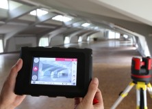
Leica 3D Disto – New Software Version 2.0 With Improved Functionality
Leica 3D Disto – New software version 2.0 with improved functionality Since more than one year, the Leica 3D Disto redefines the market for measurement tools. As being first in its category, the Leica 3D Disto is a unique tool for measurement and projection, leveling and easy scanning. The new software version 2.0 introduces new…
-
Topcon Releases the MS Series of High-Precision Robotic Total Stations in North and South America.
Topcon MS robotic series opens new era in precision measurements LIVERMORE, Calif. – Thursday, June 16, 2011 Topcon Positioning Systems (TPS) announces the release of the MS Series of high-precision robotic total stations in North and South America. “The MS ‘measuring station’ opens a new era in ultra-precision measurements,” said Denny Welch, senior vice president of…
-
Leading VFX Data Capture Company 4DMax Invest in the Latest Leica High-Definition Surveying Technology
UK based 4DMax, a leading company in the film, TV, visual FX and Forensic 3D data capture market has recently purchased the latest Leica High-Definition SurveyingTM (HDS) ScanStation C10 to enhance its 3D data capture services. Duncan Lees, Co-Owner and Director, 4DMax comments: “Working across a number of markets from big Hollywood blockbuster movies such…
-
Leica Geosystems Announces New HDS7000 Ultra High-Speed, Phase Scanner
11 April 2011 Leica Geosystems Announces New HDS7000 Ultra High-Speed, Phase Scanner (Norcross, GA April 2011) Leica Geosystems announces the HDS7000, a new phase-based laser scanner that lets users take advantage of ultra-high speed scanning for more scanning applications on more sites. The HDS7000 features key enhancements over its predecessor thanks to its rugged design, excellent…
-
Topcon GPT-3200 Series of Total Stations for Enhanced Performance
Topcon GPT-3200 series of total stations for enhanced performance LIVERMORE, Calif. – January 5, 2011 – Topcon Positioning Systems (TPS) has released two new series of reflectorless total stations – the GPT-3200NW and GPT-3200N. The GPT-3200NW series offers an array of new features that includes enhanced non-prism measurement performance, improved user interface, and increased onboard…
-
Professional Land Surveyor News-Topcon Introduces QS Robotic Total Station Series
Professional Land Surveyor News-Topcon Introduces QS Robotic Total Station Series LIVERMORE, Calif. – November 8, 2010 – Topcon Positioning Systems (TPS) introduces its new generation of robotic total stations, the QS Series (Quick Station). The QS Series – featuring the X-TRAC 8 prism tracking technology – is designed to “provide unprecedented power and speed to…
-
FARO Introduces World’s Most Accurate Break Resistant SMR as Part of Expanded Line of Laser Tracker
FARO Introduces World’s Most Accurate Break Resistant SMR as Part of Expanded Line of Laser Tracker FARO Technologies, Inc. (NASDAQ: FARO), the world’s leading provider of portable 3D measurement and imaging solutions, announced the release of the world’s most accurate break resistant spherically mounted retroreflector (SMR) as a part of their newly expanded line of…
-
Professional Land Surveyor News: Leica XPro 4.3 – HiRes Ortho Processing Reduces Flight Lines and Increases Productivity
Professional Land Surveyor News: Leica XPro 4.3 – HiRes Ortho Processing Reduces Flight Lines and Increases Productivity Today, Leica Geosystems announced that their leading line sensor workflow, the Leica XPro, has been updated with new features. Leica XPro 4.3 – HiRes Ortho Processing provides advanced ground processing from data download to image generation and users of the…
-
Professional Land Surveyor News: Topcon DL-500 Digital Level Series With First ‘Wave-and-Read’ Technology
Professional Land Surveyor News: Topcon DL-500 Digital Level Series With First ‘Wave-and-Read’ Technology Topcon Positioning Systems (TPS) announced this week that they’ve released their new DL-500 digital levels series, which uses digital ‘Wave-and-Read’ Technology for the very first time. Of course we’ve had optical ‘Wave-and-Read’ technology for eons – it’s called an instrument person looking…
-
Professional Land Surveyor News: Leica Geosystems Launches SmartNet North America
Leica Geosystems Launches SmartNet North America 1 March 2010 (Norcross, GA., 1 March 2010) – Leica Geosystems, Inc. is proud to announce the launch of SmartNet North America. SmartNet is a subscription based service offering GNSS Network RTK corrections throughout North America with Leica Geosystems directly operating, managing, and maintaining all segments of the network.…
-
Professional Land Surveyor News: Sokkia Releases the Series 50RX Reflectorless Total Stations Featuring Enhanced Environmental Durability, Increased Speed and Expanded Functionality
Sokkia Releases the Series 50RX Reflectorless Total Stations Featuring Enhanced Environmental Durability, Increased Speed and Expanded Functionality OLATHE, Kan. – Sokkia Corporation releases the new Series 50RX reflectorless total stations with a breakthrough environmental durability, increased measurement speed and an array of new features. Expanded Operating Temperature Range The high-temperature models are newly added for…