Your cart is currently empty!
Tag: Laser Scanning
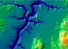
The National Land Survey of Finland Opens Topographic Datasets 1 May 2012 For Free Use
The National Land Survey of Finland Opens Topographic Datasets 1 May 2012 For Free Use The Ministry for Agriculture and Forestry issued a decree on 21 December 2011 on the fees of the National Land Survey of Finland (NLS). The decree prescribes that the NLS will open its topographic datasets to the public on 1…

GeoEye Wins Multi-year, Multi-million Dollar Russian Contract
GeoEye and ScanEx to Provide High-resolution Satellite Data for Russia’s Countrywide Cadastral Project HERNDON, Va., Jan. 4, 2012 /PRNewswire/ — GeoEye, Inc. (NASDAQ: GEOY), a leading source of geospatial information and insight, announced that it is working with its Russian partner, ScanEx Research and Development Center, to provide millions of square kilometers of high-resolution satellite…

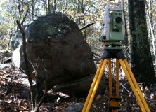
Calvada Surveying Inc Offering High Definition 3D Laser Scanning Survey for Land
Calvada Surveying Inc Offering High Definition 3D Laser Scanning Survey for Land 3d Laser Scanning Services, boundary surveys, alta acsm land title survey, ALTA survey Corona, California – Calvada Surveying Inc., a pioneering land surveying firm is offering the most extensive state of the art technology popularly known as High-Definition (HDS), or 3D Laser scanning services.…
Optech Announces Rapid Mobilization Platform for Lynx Mobile Mapper
Optech Announces Rapid Mobilization Platform for Lynx Mobile Mapper Toronto, Canada, September 27, 2011 Optech Incorporated, the world’s leading manufacturer of advanced lidar and camera survey instruments, is pleased to announce a new lightweight, state-of-the-art mounting platform for its Lynx Mobile Mapper. The newly designed rack features rigid mounting points and latching that virtually eliminate…
Professional Land Surveyor Weekly Roundup November 13, 2011
Professional Land Surveyor Weekly Roundup: Professional Land Surveyor Source Twitter Weekly Updates for 2011-11-13 Knowing Your Numbers-How to Develop Project Metrics for Your Land Surveying Company Leica Viva – SmartWorx Viva – Image Notes Video Professional Land Surveyor Weekly Roundup November 6, 2011 Professional Land Surveyor Source Twitter Weekly Updates for 2011-11-06 New TigerSupplies Showroom…
Professional Land Surveyor Weekly Roundup November 6, 2011
Professional Land Surveyor Weekly Roundup: Professional Land Surveyor Source Twitter Weekly Updates for 2011-11-06 New TigerSupplies Showroom for High-Quality Architectural, Engineering and Survey Equipment Soyuz Launched With First Two Geopositioning Galileo Satellites House Small Business Committee Ask the FCC to Halt Waiver on LightSquared Proposal Javad Ashjaee, GPS Pioneer and JAVAD Founder, Admits to GPS…
New Version of Topcon ScanMaster Software Improves Scanning Performance
New Version of Topcon ScanMaster Software Improves Scanning Performance LIVERMORE, Calif. – Thursday, October 27, 2011 Topcon Positioning Systems (TPS) has released a new version of software used with Topcon’s GLS series of laser scanners – ScanMaster v2.5. The new version was designed to improve existing features, add new functions, and broaden applications for scanning. “We’ve…
Optech Announces New Airborne Laser Terrain Mappers (ALTM) Models: Orion M/C 300
Toronto, Canada, September 26, 2011 Optech Incorporated is pleased to announce the latest addition to its innovative line of airborne laser terrain mappers, the ALTM Orion M/C 300. Available in two models, the Orion M300 and C300 are specifically designed for mid-altitude engineering and low-altitude corridor applications respectively. Both models are now equipped with multipulse…
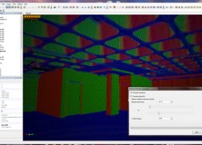
ClearEdge3D Wins Prestigious National Science Foundation Grant for Automated Feature Extraction Research
Funding will greatly improve the company’s feature extraction technology; goal is to virtually eliminate manual modeling of facilities, buildings and entire cities Herndon, Virginia — September 21, 2011 — ClearEdge3D today announced that it has won a research grant from the National Science Foundation (NSF) to further develop its technology in the rapidly evolving field of…