Your cart is currently empty!
Tag: Laser Scanning
Geospatial Social Media Recap April 25, 2015
Here are a few of the more interesting or amusing (at least to me) surveying, mapping, geomatics, technology and other generally geospatial related social media updates from around the interwebs (with occasional tangents). Geospatial updates more fun than a barrel full of monkeys… monkeys with maps that is. (Click to Tweet) Terrane Aerial Mapping via…
Geov8 2015 Virtual Expo Announced by Colburn Strategic Partners for August 15, 2015
An Online Virtual Geoinnovation Event Showcasing New and Innovative Geospatial Technology 04/12/2015 – The Geov8 2015 Virtual Expo is an online virtual geoinnovation event showcasing new and innovative geospatial technologies. This event will be held by Colburn Strategic Partners, experts in geospatial technology integration. There will be industry leaders and specialists in geospatial tech presenting…
Laser Scanning Drones: XactSense is First to Fly Velodyne’s New Low-Cost LIDAR “Puck”
XactSense Inc. has developed a new platform for low-altitude aerial mapping using the newly released Velodyne LIDAR VLP-16 “Puck”. Drone LIDAR mapping for the masses is here. Providence, Rhode Island (PRWEB) March 02, 2015 XactSense, Inc. has developed a new platform for low-altitude aerial mapping using the newly released Velodyne LIDAR VLP-16 “Puck”. Drone LIDAR…
New Leica MultiWorx for AutoCAD: Easy Creation of Survey Deliverables from Laser Scanning and Imaging with the New Leica Nova MS50 MultiStation
(Heerbrugg, Switzerland/Las Vegas,USA, 5 June 2013) – Leica Geosystems’ new Leica Nova MS50 MultiStation, announced at HxGN Live, enables surveyors to easily perform 3D laser scanning tasks and work with point clouds in 3D. To help newcomers to laser scanning take full advantage of the system’s capabilities, Leica Geosystems announces Leica MultiWorx for AutoCAD, an easy-to-learn…
ZEB1 Hand Held Mapping System Used to Explore Aboriginal Caves
ZEB1, the world’s first truly mobile handheld rapid laser mapping system has been used to explore Aboriginal cave markings in South Australia. The strange markings, called finger flutings, were thought to have been left in the Koonalda Cave between about 30,000 and 10,000 years ago.

Surveyor’s Saturday Serendipity: Center City, Pa Flythrough Using Pointools and 3ds Max
A wee bit of Surveyor’s Saturday Serendipity with a Laser Scanning Video by Control Point Associates described on their Youtube Channel as: “This is a unique flythrough using Pointools and 3ds Max to give a first person representation of an entire city block and the inside of a hallway. Control Point Associates” Watch the Surveyor’s Saturday Serendipity: Center…

Surveyor’s Saturday Serendipity: Mini-UAV-Based Photogrammetry and Laser Scanning Video
A wee bit of Surveyor’s Saturday Serendipity with a Mini-UAV-Based Photogrammetry and Laser Scanning Video. I love this technology, which could become an industry game-changer, allowing entry into the aerial mapping market to land surveying and geomatic companies. Watch the Surveyor’s Saturday Serendipity: Mini-UAV-Based Photogrammetry and Laser Scanning Video

Leica Geosystems Laser Scanning Video: Chapter 1 of 3 – The Basics
Laser Scanning: Chapter 1 of 3 – The Basics This professionally produced, educational HD video overview of 3D laser scanning includes film footage of its use in the field for scene capture and in the office for processing laser scans into deliverables such as drawings, models, etc.

Merrick & Company Wins First Place in the Leica Geosystems Civil/Survey Category of the “High Definition Surveying (HDS) Plan” Contest
SURVEY TEAM RECEIVES 1ST PLACE COLORADO – Merrick & Company won first place in the civil/survey category of the “High Definition Surveying (HDS) Plan” contest, hosted by Leica Geosystems. The annual event is part of a worldwide conference, Hexagon 2012. The awards program allows Leica HDS/laser scanning users to submit posters with laser scanning deliverables in…

Drombeg Stone Circle Laser Scanning Video
Animation of a laser scan survey of Drombeg Stone Circle, Glandore, Co.Cork. Surveyed using a Faro Focus 120 scanner by the Discovery Programme as part of the 3D-ICONS project. The animation, generated in Pointools shows the point cloud data rendered with the INTENSITY values which can improve the definition of features in the model.

Topcon Technology Supports One-Of-A-Kind Preservation, Renovation Project In Pompeii
Topcon Positioning Systems (TPS) and its president and CEO, Ray O’Connor, were honored by the City of Pompeii, Italy and four Italian universities for assisting with the “preservation and renovation” of the historic landmark of Pompeii. Old Pompeii, one of Italy’s major tourist attractions with 25,000 visitors a day, was literally “falling apart” after 2011’s…
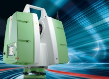
Leica ScanStation P20: Three World’s Firsts in a Ultra-High Speed Laser Scanner to Deliver Unprecedented 3D Point Quality and Productivity
Leica ScanStation P20: Three World’s Firsts in a Ultra-High Speed Laser Scanner to Deliver Unprecedented 3D Point Quality and Productivity (Heerbrugg/Switzerland and Hanover/Germany, 9th October 2012) – Leica Geosystems today announces the Leica ScanStation P20, bringing unprecedented performance to ultra-high speed laser scanning. Developed and manufactured by industry pioneer and leader, the Leica ScanStation P20 provides…

Space Shuttle Endeavour LA Move – 3D Laser Scanning
Space Shuttle Endeavour LA Move – 3D Laser Scanning This video contains 3D mobile scanning animation for the Space Shuttle move.
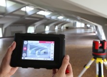
Leica 3D Disto – New Software Version 2.0 With Improved Functionality
Leica 3D Disto – New software version 2.0 with improved functionality Since more than one year, the Leica 3D Disto redefines the market for measurement tools. As being first in its category, the Leica 3D Disto is a unique tool for measurement and projection, leveling and easy scanning. The new software version 2.0 introduces new…

DMK Associates Brings Leica ScanStation C5 Scanner to SW Florida
Regional leader DMK Associates Inc. chooses a Leica Geosystems ScanStation C5 scanner to equip Southwest Florida’s first permanently-based laser scanning crew. (Norcross, Ga./Heerbrugg, 2 July 2012) – DMK Associates, Inc., a 28-person full-service consulting firm serving counties and municipalities in Southwest Florida, recently established the region’s first dedicated laser scanning crew and chose the Leica ScanStation…

Integration of Laser Scanner Data & Mobile Mapping Data : Faro Focus 3D & Topcon IP-S2 Video
I’m just a sucker for a good laser scanning video, and here’s a new one. Watch the Integration of Laser Scanner Data & Mobile Mapping Data : Faro Focus 3D & Topcon IP-S2 Video

Professional Land Surveyor Weekly Roundup March 25, 2012
Professional Land Surveyor Weekly Roundup: Professional Land Surveyor Premium Post Updates How To Create a Standout Professional Land Surveyor Company Marketing Strategy Professional Land Surveyor Weekly Roundup March 18, 2012 A Few Older Posts, Too: Professional Land Surveyor Weekly Roundup March 11, 2012 AutoCAD Civil 3D How To Trim Image to a Surface Border Video…
Professional Land Surveyor Weekly Roundup March 11, 2012
Professional Land Surveyor Weekly Roundup: AutoCAD Civil 3D How To Trim Image to a Surface Border Video High-Definition Survey (HDS) Laser Scanning on Amtrak Video Land Surveying 911: Should I Pay For AutoCAD Civil 3D Training Or Try To Learn It On My Own? Professional Land Surveyor Weekly Roundup March 4, 2012 What Is The…
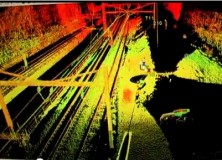
High-Definition Survey (HDS) Laser Scanning on Amtrak Video
High-Definition Survey (HDS) Laser Scanning on Amtrak Video “Chilton Engineering offers High-Definition Survey (HDS) laser scanning expertise on Amtrak corridor for City of Philadelphia Department of Streets bridge replacement project. Our efficient field survey delivered detailed data on catenary towers, horizontal and vertical track alignment, utilities, bridge cross-sections, abutments and more without disruption to rail…

UK Police Forces Embrace Leica Geosystems ScanStation C10 3D Laser Scanning
UK Police Forces Embrace Leica ScanStation C10 3D Laser Scanning 6 January 2012 (Milton Keynes, UK 5th January 2012) – Leica Geosystems is pleased to announce the largest ever order of Leica ScanStation C10’s as UK Police Forces embrace High Definition SurveyingTM (HDS). The scanners will be supplied as part of a £2.7 million investment from the Department…