Your cart is currently empty!
Tag: Improves
-

Trimble Survey Software Improves Productivity for the Office and Field
Trimble’s Survey Software Improves Productivity for the Office and Field Trimble (NASDAQ:TRMB) introduced today new versions of its office and field surveying software—Trimble® Business Center Software version 2.70 and Trimble Access™ software version 2012.10. The software is part of Trimble’s portfolio of Connected Site® survey solutions. The new software enhancements allow surveyors to collect, share…
-
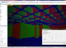
New Version of Topcon ScanMaster Software Improves Scanning Performance
New Version of Topcon ScanMaster Software Improves Scanning Performance LIVERMORE, Calif. – Thursday, October 27, 2011 Topcon Positioning Systems (TPS) has released a new version of software used with Topcon’s GLS series of laser scanners – ScanMaster v2.5. The new version was designed to improve existing features, add new functions, and broaden applications for scanning. “We’ve…