Tag: GPS
-
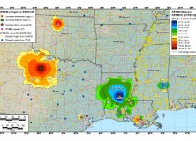
GEOID12 Error Analysis Complete and GEOID12A Model Developed
Here’s an important notice from The National Geodetic Survey (NGS) concerning the new GEOID12 model: The National Geodetic Survey has determined that the GEOID12 model was developed using erroneous input control points, primarily in the Gulf Coast region. NGS immediately corrected these errors and developed a replacement model: GEOID12A. GEOID12A is now available for public…
-

Leica Viva GS08plus – Lightest Cable-Free High-Accuracy GNSS System
Leica Viva GS08plus – Lightest cable-free high-accuracy GNSS system (Heerbrugg/Switzerland, 31 July 2012) – Leica Geosystems is pleased to announce a new GNSS solution to its successful Viva GNSS family. The Leica Viva GS08plus is the smallest and lightest cable-free high-accuracy GNSS system. Being light weight and ideally balanced, the Leica Viva GS08plus delivers ergonomic…
-

The National Geodetic Survey Improves the National Spatial Reference System with Simultaneous Major Product Releases
The National Geodetic Survey Improves the National Spatial Reference System with Simultaneous Major Product Releases In the first week of July, NOAA’s National Geodetic Survey (NGS) released the results of three major improvements to the National Spatial Reference System (NSRS). The NSRS is the consistent coordinate system that defines latitude, longitude, height, scale, gravity, and…
-

NGS Releases New Geoid Model to Serve Surveying, Engineering, and Scientific Communities
NGS Releases New Geoid Model to Serve Surveying, Engineering, and Scientific Communities In the last week, the National Geodetic Survey has released a new height transformation model for surveyors, engineers, and the scientific community involved in water flow and the determination of heights with respect to mean sea level. The new “GEOID12” model, implemented in…
-

Drone GPS Spoofing Experiment
University of Texas at Austin GPS Spoofing experiment “GPS Spoofing experiment performed at the University of Texas at Austin by Dr Humphries. Actual GPS is changed to “confuse” the drone.” Source: Youtube Watch the Video
-

LightSquared Backer Falcone Charged By SEC With Securities Fraud
This week, the U.S. Securities and Exchange Commission (SEC) filed fraud charges against LightSquared backer Philip Falcone and his advisory firm, Harbinger Capital Partners LLC. The hedge fund owns most of the troubled LightSquared. Philip A. Falcone and Harbinger Charged with Securities Fraud
-

Leica Geosystems Announces Leica RCD30 Multi-Head Camera Concept
Leica Geosystems announces Leica RCD30 multi-head camera concept (Heerbrugg, 6 June 2012) – Leica Geosystems, the world’s leading manufacturer of airborne mapping solutions, announced today that it is expanding the very popular Leica RCD30 series of medium format cameras by adding dual-head and penta-head solutions to the portfolio. The Leica RCD30 combines unique design features such…
-
Trimble Company, Cengea Solutions, Awarded Oregon Department of Forestry Contract
Trimble Company, Cengea Solutions, Awarded Oregon Department of Forestry Contract to Provide State Forest Revenue System SUNNYVALE, Calif., June 7, 2012—Trimble (NASDAQ: TRMB) announced today that Cengea Solutions, a Trimble Company, has been awarded a contract by the Oregon Department of Forestry (ODF) to provide a State Forest Revenue System (SFRS) to support the agency…
-

Esri GPS Base Station Joins National Continuously Operating Reference Station (CORS) Network
Real-Time, Precise Data Will Serve Professionals in the Redlands Community Redlands, California—Esri recently installed a GPS base station to assist its GIS developers and to support surveyors, engineers, scientists, and those in public works and public safety in the community surrounding the Esri campus in Redlands, California. The base station, named GISA, has been accepted…
-

Professional Land Surveyor Vlog 004-Survey Earth in a Day Interview
PLS Vlog 004-Survey Earth in a Day Interview In this Professional Land Surveyor Vlog I’m introducing a new format of Professional Land Surveyor Spotlight interviews. I hope you enjoy the interview and I will have more from time to time. In this inaugural Professional land Surveyor Spotlight, I interview Scott Warner, RLS, and VP Senior Director &…
-

Professional Land Surveyor Top 10 At Ten
Top 10 at 10 Here are today’s Top 10 trending posts as of 10 tonight: AutoCAD Civil 3D 2013 Guts Google Earth The Professional Land Surveyor Podcast Episode 4 Trimble Survey Software Improves Productivity for the Office and Field AutoCAD Civil 3D 2013 Survey Hotfix Video AutoCAD Civil 3D for Land Surveyors Coordinate Systems Refresher…
-
Trimble Survey Software Improves Productivity for the Office and Field
Trimble’s Survey Software Improves Productivity for the Office and Field Trimble (NASDAQ:TRMB) introduced today new versions of its office and field surveying software—Trimble® Business Center Software version 2.70 and Trimble Access™ software version 2012.10. The software is part of Trimble’s portfolio of Connected Site® survey solutions. The new software enhancements allow surveyors to collect, share…
-

Professional Land Surveyor Weekly Roundup April 22, 2012
Professional Land Surveyor Weekly Roundup: AutoCAD Civil 3D and FEMA Floodplain Maps Video Trimble Introduces New Positioning Solution for Tunnel Construction AutoCAD Civil 3D Working With Images And Surfaces Professional Land Surveyor Learning Center Course Professional Land Surveyor Weekly Roundup April 15, 2012 AutoCAD Civil 3D 2013 Guts Google Earth MicroSurvey FieldGenius 2012 Service Pack…
-
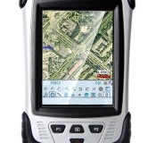
CHC Releases the LT30 GPS/GIS Handheld Collector
CHC Releases the LT30 GPS/GIS Handheld Collector Shanghai, China – (April 2nd, 2012) – CHC’s new LT30 series enters the GIS data collection market with a cost-effective, rugged and connected GPS/GIS handheld collector for a wide range of applications such as natural resources, forestry, utilities, agriculture, emergency response… Designed for real outdoor conditions, LT30 combines superb brightness…
-

Leica Geosystems Introduces The Latest Version 4.2 Of Its Leica Spider Software Suite For GNSS Networks and Reference Stations
Leica Geosystems introduces the latest version 4.2 of its Leica Spider Software Suite for GNSS Networks and Reference Stations Leica Geosystems is pleased to release the new version 4.2 of its market leading Leica Spider software suite. The globally used solution for GNSS RTK networks is being continually enhanced and developed following the market needs…
-

Professional Land Surveyor Weekly Roundup April 8, 2012
Professional Land Surveyor Weekly Roundup: Trimble Acquires Gatewing to Expand its Survey Solutions to Include Aerial Mapping AutoCAD Civil 3D 2013 Unwrapped Video LightSquared Bankruptcy Now A Possible Option For Investor Phil Falcone Hemisphere GPS Introduces New miniEclipse™ Compact OEM Modules with GNSS Support Get The EricColburn.com 2012 Marketing Kit How Many Computer Monitors Do…
-

Trimble Acquires Gatewing to Expand its Survey Solutions to Include Aerial Mapping
Trimble Acquires Gatewing to Expand its Survey Solutions to Include Aerial Mapping SUNNYVALE, Calif., April 6, 2012—Trimble (NASDAQ:TRMB) announced today that it has acquired privately-held Gatewing of Gent, Belgium, a provider of lightweight unmanned aerial vehicles (UAV) for photogrammetry and rapid terrain mapping applications. The acquisition broadens Trimble’s industry-leading platforms for surveying solutions. Financial terms…
-
LightSquared Bankruptcy Now A Possible Option For Investor Phil Falcone
Phil Falcone, who invested around $3 billion in LightSqaured through his hedge fund Harbinger Capital Partners, is now considering placing the troubled broadband wireless company in bankruptcy.
-

Hemisphere GPS Introduces New miniEclipse™ Compact OEM Modules with GNSS Support
Hemisphere GPS Introduces New miniEclipse™ Compact OEM Modules with GNSS Support CALGARY, March 28, 2012 /CNW/ – (TSX: HEM) Today, Hemisphere GPS announces the Eclipse™ P300 and Eclipse P301 OEM modules – the next generation high-performance compact modules for RTK GNSS applications. Based on new Hemisphere GPS multi-function application firmware and Eclipse GNSS multi-constellation technology, P300 and P301 provide…
-

Professional Land Surveyor Premium Post Updates
Professional Land Surveyor Premium Post Updates I was just updating the Premium Membership Specials page by adding a list of all the Premium Posts I’ve published to date. I did not realize that they now add up to over 40 premium posts, how time flies when you’re having fun (and I am!). To sign up,…