Tag: Engineering
-

McKim & Creed Purchases Assets of United Engineering Group
Nationally Recognized MEP Firm, United Engineering Group, Inc., Joins McKim & Creed January 1, 2013 Effective January 1, 2013, McKim & Creed has purchased the assets of United Engineering Group, Inc., a well-respected mechanical, electrical, plumbing and fire protection engineering firm.
-

Merrick & Company Wins First Place in the Leica Geosystems Civil/Survey Category of the “High Definition Surveying (HDS) Plan” Contest
SURVEY TEAM RECEIVES 1ST PLACE COLORADO – Merrick & Company won first place in the civil/survey category of the “High Definition Surveying (HDS) Plan” contest, hosted by Leica Geosystems. The annual event is part of a worldwide conference, Hexagon 2012. The awards program allows Leica HDS/laser scanning users to submit posters with laser scanning deliverables in…
-

AutoCAD Civil 3D Custom Template Setup & Training Done Right
A large organization asked me this week if I could give them AutoCAD Civil 3D custom template setup and training. They’re looking to use AutoCAD Civil 3D in their workflows. What struck me about their request is they recognized that a successful implementation of AutoCAD Civil 3D is more than simply setting up a template, and that training…
-
Autodesk 123D Catch for iPhone Lets Everyone Create 3D Printed Models with Photos
App Expands on iOS to include iPhone SAN FRANCISCO–(BUSINESS WIRE)–Autodesk, Inc. launched the new free* Autodesk 123D Catch app for iPhone on the App Store. Complementing the iPad, desktop and web app versions, the app lets users take photos from their camera on iPhone and upload them to the cloud where the photos are converted…
-
Eagle Point Support for 2013 Versions of AutoCAD Civil 3D and Autodesk Revit Solutions Now Available
Support for 2013 Versions of AutoCAD Civil 3D and Autodesk Revit Solutions Now Available DUBUQUE, Iowa, September 4, 2012 – Eagle Point Software Corporation, an Autodesk AEC Industry Partner, announced the addition of AutoCAD Civil 3D 2013 and Autodesk Revit 2013 resources to Pinnacle Series, which enables AEC organizations to immediately take advantage of the new…
-
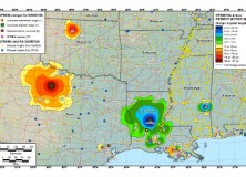
GEOID12 Error Analysis Complete and GEOID12A Model Developed
Here’s an important notice from The National Geodetic Survey (NGS) concerning the new GEOID12 model: The National Geodetic Survey has determined that the GEOID12 model was developed using erroneous input control points, primarily in the Gulf Coast region. NGS immediately corrected these errors and developed a replacement model: GEOID12A. GEOID12A is now available for public…
-

Professional Land Surveyor Weekly Roundup July 29, 2012
Professional Land Surveyor Weekly Roundup: Basic AutoCAD Civil 3D Setup Planning and Preparation How To Stop Avoiding Business And Professional Realities, Embrace Change, And Focus Your Goals Professional Land Surveyor Weekly Roundup July 22, 2012 The National Geodetic Survey Improves the National Spatial Reference System with Simultaneous Major Product Releases Earn a Degree in the…
-

The National Geodetic Survey Improves the National Spatial Reference System with Simultaneous Major Product Releases
The National Geodetic Survey Improves the National Spatial Reference System with Simultaneous Major Product Releases In the first week of July, NOAA’s National Geodetic Survey (NGS) released the results of three major improvements to the National Spatial Reference System (NSRS). The NSRS is the consistent coordinate system that defines latitude, longitude, height, scale, gravity, and…
-

NGS Releases New Geoid Model to Serve Surveying, Engineering, and Scientific Communities
NGS Releases New Geoid Model to Serve Surveying, Engineering, and Scientific Communities In the last week, the National Geodetic Survey has released a new height transformation model for surveyors, engineers, and the scientific community involved in water flow and the determination of heights with respect to mean sea level. The new “GEOID12” model, implemented in…
-

Announcing New AutoCAD Civil 3D 911 Series
AutoCAD Civil 3D 911-Exploring, Discussing & Solving AutoCAD Civil 3D Problems Today, I’m announcing a new series of articles dedicated to solving your AutoCAD Civil 3D 911 problems. As a recurring feature, these AutoCAD Civil 3D 911 articles allow us to explore and discuss your routine, or unique, AutoCAD Civil 3D issues. AutoCAD Civil 3D 911 Series…
-

Create Alignment From Objects in AutoCAD Civil 3D Video
Create Alignment From Objects in AutoCAD Civil 3D Video This AutoCAD Civil 3D for Land Surveyors Video shows you how to create an Alignment from Objects in AutoCAD Civil 3D. Watch the Create Alignment From Objects in AutoCAD Civil 3D Video
-

AutoCAD Civil 3D Template Sale
AutoCAD Civil 3D 2011 and 2012 Templates Sale With the release of the first of our 2013 AutoCAD Civil 3D templates, we’re putting our 2011 and 2012 AutoCAD Civil 3D Template on sale. 25% Off 2012 AutoCAD Civil 3D Templates All of our 2012 AutoCAD Civil 3D are marked down by 25%. 2012 AutoCAD Civil 3D…
-

AutoCAD Civil 3D 2013 Manual Point Creation Video
AutoCAD Civil 3D 2013 Manual Point Creation Video This AutoCAD Civil 3D for Land Surveyors Video shows you how to do Manual Point Creation. Watch the AutoCAD Civil 3D 2013 Manual Point Creation Video
-

AutoCAD Civil 3D 2013 Add Viewport Scales Video
AutoCAD Civil 3D 2013 Add Viewport Scales Video This AutoCAD Civil 3D for Land Surveyors Video shows you how to Add Viewport Scales in Paperspace. Creating custom Viewport Scales is easy, once you know how. Watch the AutoCAD Civil 3D 2013 Add Viewport Scales Video
-

AutoCAD Civil 3D Filedia Command Video
AutoCAD Civil 3D Filedia Command Video This AutoCAD Civil 3D for Land Surveyors Video shows you how to use the FILEDIA command. I believe this command works for all flavors of AutoCAD. The FILEDIA command controls the file dialog boxes, turning them either on or off, like those used when opening and saving drawings. Sometimes,…
-
Customized AutoCAD Civil 3D Survey Templates For Land Surveyors, Engineers and Designers
Can your business afford to waste time and money setting up AutoCAD Civil 3D? AutoCAD Civil 3D is a great program …. Once it’s set up and you know how to use it! BUT, getting to that point takes a serious investment in your time, which means lost productivity, billing, and money. And, what if…
-

AutoCAD Civil 3D 2013 Paste Surfaces Using The Ribbon Video
AutoCAD Civil 3D 2013 Paste Surfaces Using The Ribbon Video This AutoCAD Civil 3D for Land Surveyors Video is an update to my last video (AutoCAD Civil 3D 2013 Paste Surfaces Video – see link below), in which, I forgot to show you how to paste surfaces using the Ribbon in AutoCAD Civil 3D. You…
-

AutoCAD Civil 3D 2013 Paste Surfaces Video
AutoCAD Civil 3D 2013 Paste Surfaces Video In this AutoCAD Civil 3D for Land Surveyors Video, I show you how to paste surfaces in AutoCAD Civil 3D. You can use this technique to merge design and/or as-built surfaces into your original existing conditions surface. Once you paste the surfaces into the first surface, you will…
-

Professional Land Surveyor Top 10 At Ten
Top 10 at 10 Here are today’s Top 10 trending posts as of 10 tonight: AutoCAD Civil 3D 2013 Guts Google Earth The Professional Land Surveyor Podcast Episode 4 Trimble Survey Software Improves Productivity for the Office and Field AutoCAD Civil 3D 2013 Survey Hotfix Video AutoCAD Civil 3D for Land Surveyors Coordinate Systems Refresher…
-
AutoCAD Civil 3D 2013 Survey Hotfix Video
Get It While It’s Hot, New AutoCAD Civil 3D 2013 Survey Hotfix! Well, it didn’t take long for a software bug and an AutoCAD Civil 3D survey hotfix. “This hotfix resolves an issue with the Survey Figures Property Dialog. In the lower section of the panel you can now see the vertex properties for chain type…