Your cart is currently empty!
Tag: Database
-

AutoCAD Civil 3D for Land Surveyors Coordinate Systems Refresher Video
In this oldie but goodie video, I show you how to set up coordinate systems in AutoCAD Civil 3D Drawings & Survey Databases. If you’re new to AutoCAD Civil 3D, properly setting up your Drawing and Survey Databases is the most important thing you need to do. While this video shows you how to set up…
-

Create Survey Point Groups in AutoCAD Civil 3D Survey Databases Video
Create Survey Point Groups in AutoCAD Civil 3D Survey Databases In this AutoCAD Civil 3D for Land Surveyors Video, I show you how to Create Survey Point Groups in AutoCAD Civil 3D Survey Databases. Survey Point Groups allow you to filter, organize and more easily work with Survey Database Points in your AutoCAD Civil 3D…
-

AutoCAD Civil 3D Set Survey Databases Working Folder Video
AutoCAD Civil 3D Set Survey Databases Working Folder Video In this AutoCAD Civil 3D for Land Surveyors Video I will show you how to set the Survey Databases Working Folder. Watch the Video
-
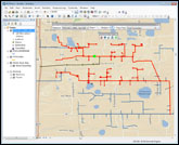
New Century Software Releases Geometric Network Synchronizer
Operators using PODS gathering systems & complex transmission pipeline systems can now automatically keep multiple geometric networks synchronized Fort Collins, CO. January 11, 2011. New Century Software (http://www.newcenturysoftware.com) announces the release of its new product, Geometric Network Synchronizer. Geometric Network Synchronizer is both an Esri ArcMap extension and a server component that builds and maintains…
-

Autodesk 2012 Content Explorer Service Hot Fix 2
Autodesk 2012 Content Explorer Service Hot Fix 2 Here’s an AutoCAD 2012 hot fix which will fix issues you might be experiencing with Autodesk 2012 Content Explorer. Autodesk 2012 Content Explorer Service Hot Fix 2 This hotfix applies to the Autodesk 2012 Content Explorer Service (Public and Personal) and addresses the following issues: In some cases…
-

5 AutoCAD Civil 3D Settings Professional Land Surveyors Need To Know
It’s frustrating as heck trying to learn how to setup and use AutoCAD Civil 3D and also get projects completed. You’re not a professional student; you’re a Professional Land Surveyor, Engineer, Designer, etc. Whatever you are, you’re trying to get the job done right and earn a living! Depending on what’s in your AutoCAD Civil…