Tag: ArcGIS
-

New Build of ArcGIS Explorer Desktop Tightens Integration with ArcGIS Online
Easier Sharing, Attribute Table Display, and New Presentation Tools Are Among Improvements The most recent ArcGIS Explorer Desktop release includes new features and enhancements to make it a more powerful tool in an enterprise GIS, including content sharing via ArcGIS Online, tabular information display, and new presentation tools. ArcGIS Explorer Desktop is a free GIS viewer that…
-

ArcGIS for AutoCAD Offers Advanced CAD and GIS Interoperability
New Version Introduces Geodatabase Editing August 22, 2012 Redlands, California—The latest release of ArcGIS for AutoCAD, Esri’s free AutoCAD plug-in, improves the ability to exchange data and information between the ArcGIS and AutoCAD platforms. ArcGIS for AutoCAD users with read/write access to ArcGIS for Server feature services can now edit geodatabases through AutoCAD. This enables…
-
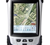
CHC Releases the LT30 GPS/GIS Handheld Collector
CHC Releases the LT30 GPS/GIS Handheld Collector Shanghai, China – (April 2nd, 2012) – CHC’s new LT30 series enters the GIS data collection market with a cost-effective, rugged and connected GPS/GIS handheld collector for a wide range of applications such as natural resources, forestry, utilities, agriculture, emergency response… Designed for real outdoor conditions, LT30 combines superb brightness…
-

Esri ELA Supports Maryland’s Nationally Recognized GIS Program
ArcGIS Software Empowers Agencies to Deliver Transparency and Accountability January 4, 2012 Redlands, California—The State of Maryland has acquired an Esri enterprise license agreement (ELA) that provides unlimited access to ArcGIS software to staff in its agencies. Under Governor Martin O’Malley’s leadership, the state uses GIS for much of its work including groundbreaking transparency and…
-

Professional Land Surveyor Weekly Roundup January 1, 2012
Professional Land Surveyor Weekly Roundup: ArcGIS Online Overview Video Video-Has The Land Surveying Industry Let You Down? Carlson Takeoff R5 Speeds Up Converting PDF Files & Much More Trimble’s Kirkland to Discuss LightSquared Issue in MAPPS Winter Meeting Keynote Address 4 Ingredients for a Successful Professional Land Surveyor Business Web Presence Professional Land Surveyor Survey-Has…
-

ArcGIS Online Overview Video
Create, find, use, and share maps, applications, and tools with everyone. Watch this ESRI ArcGIS Online Overview Video
-

New Esri Basemap Highlights Thematic Content
Free Light Gray Canvas Basemap Service Now Available October 6, 2011 User data shown on top of Light Gray Canvas map is easier to distinguish compared to user data displayed on busier maps