Your cart is currently empty!
Tag: Aerial

Surveyor’s Saturday Serendipity: Drones for Aerial Surveying+EPIC Launcher!
A wee bit of Surveyor’s Saturday Serendipity of aerial surveying with an EPIC launcher!. Come fly with me, let’s fly, let’s fly away……
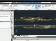
AutoCAD Civil 3D Drape Images Over A Surface Video
AutoCAD Civil 3D Drape Images Over A Surface Video This AutoCAD Civil 3D for Land Surveyors Video shows you how to drape Images over a Surface.

AutoCAD Civil 3D How To Trim Image to a Surface Border Video
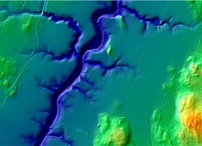
AutoCAD Civil 3D How To Trim Image to a Surface Border This AutoCAD Civil 3D for Land Surveyors Video shows you how to trim an image, like a geo-referenced aerial photograph or orthophoto, to a Civil 3D Border.

AutoCAD Civil 3D How To Insert Geo-Referenced Images Video
AutoCAD Civil 3D How To Insert Geo-Referenced Images This AutoCAD Civil 3D for Land Surveyors Video shows you how to insert geo-referenced images, like aerial photographs or orthophotos. AutoCAD Civil 3D, being built on Map 3D, allows you to easily use Geographic Information System (GIS) data into your land surveying, design and engineering projects. All you…
The National Land Survey of Finland Opens Topographic Datasets 1 May 2012 For Free Use
The National Land Survey of Finland Opens Topographic Datasets 1 May 2012 For Free Use The Ministry for Agriculture and Forestry issued a decree on 21 December 2011 on the fees of the National Land Survey of Finland (NLS). The decree prescribes that the NLS will open its topographic datasets to the public on 1…

Professional Land Surveyor Weekly Roundup November 27, 2011
Professional Land Surveyor Weekly Roundup: AutoCAD Civil 3D 2012 Update 1 Professional Land Surveyor Weekly Roundup November 20, 2011 Professional Land Surveyor Source Twitter Weekly Updates for 2011-11-20 Leica Viva GNSS Video Geographic and Land Information Society Board Votes to Continue GLIS as a Separate Organization Trimble Offers Custom Topographic, Aerial and Hybrid Map Prints…

Professional Land Surveyor Weekly Roundup November 20, 2011
Professional Land Surveyor Weekly Roundup: Professional Land Surveyor Source Twitter Weekly Updates for 2011-11-20 Leica Viva GNSS Video Geographic and Land Information Society Board Votes to Continue GLIS as a Separate Organization Trimble Offers Custom Topographic, Aerial and Hybrid Map Prints Esri Press Book Presents Latest Crime Mapping and Analysis Methods NSPS and ACSM Action…

Trimble Offers Custom Topographic, Aerial and Hybrid Map Prints
Trimble Offers Custom Topographic, Aerial and Hybrid Map Prints