Category: Topcon
-

Topcon Announces Direct Cloud-Link Between MAGNET Enterprise and AutoCAD WS
New capability streamlines the availability of critical field information onto mobile devices Topcon Positioning Systems, Inc., (TPS) a global leader in precision positioning technology, has announced the first results of its collaboration with Autodesk, Inc., a leader in 3D design, engineering and entertainment software: A direct link to AutoCAD WS within Topcon’s MAGNET™ Enterprise cloud…
-

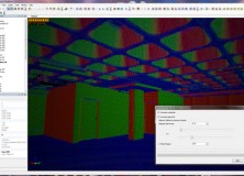
Topcon Releases ScanMaster CAD Link for GLS-1500
Topcon Releases ScanMaster CAD Link for GLS-1500 LIVERMORE, Calif. – November 27, 2012 – Topcon Positioning Systems (TPS) announces the release of ScanMaster CAD Link which provides users with an interactive link between ScanMaster and AutoCAD® software and enables efficient feature extraction and drawing of objects. CAD Link is an optional extension for ScanMaster software…
-

Topcon IP-S2 Compact+ 3D Mobile Mapping System for a Wide Range of Applications
Topcon IP-S2 Compact+ 3D mobile mapping system for a wide range of applications LIVERMORE, Calif. – October 11, 2012 – Topcon Positioning System (TPS) introduces the new IP-S2 Compact+, an innovative mobile mapping system to accurately measure objects even in adverse weather conditions and enclosed job sites such as tunnels and mines.
-

Topcon Launches TopNET Live Website
Topcon launches TopNET live website LIVERMORE, Calif. – Topcon Positioning Systems (TPS) announces the launch of the new TopNET live website. TopNET live is the new name for the restructuring of Topcon’s GNSS network business, and global GNSS services. The service offers subscription-based, real-time GNSS network RTK and DGPS subscriptions, with high quality GPS and…
-

Professional Land Surveyor Weekly Roundup November 13, 2011
Professional Land Surveyor Weekly Roundup: Professional Land Surveyor Source Twitter Weekly Updates for 2011-11-13 Knowing Your Numbers-How to Develop Project Metrics for Your Land Surveying Company Leica Viva – SmartWorx Viva – Image Notes Video Professional Land Surveyor Weekly Roundup November 6, 2011 Professional Land Surveyor Source Twitter Weekly Updates for 2011-11-06 New TigerSupplies Showroom…
-
New Version of Topcon ScanMaster Software Improves Scanning Performance
New Version of Topcon ScanMaster Software Improves Scanning Performance LIVERMORE, Calif. – Thursday, October 27, 2011 Topcon Positioning Systems (TPS) has released a new version of software used with Topcon’s GLS series of laser scanners – ScanMaster v2.5. The new version was designed to improve existing features, add new functions, and broaden applications for scanning. “We’ve…
-

The Topcon Group Announces Magnet Cloud-Based Software for Real-Time Collaboration
The Topcon Group announces Magnet cloud-based software for real-time collaboration LIVERMORE, Calif. –Thursday, October 13, 2011 The Topcon Group announces a unique cloud-based enterprise solution and cloud-enabled family of software applications – Magnet™ – for all precise positioning projects. The new software solution makes it possible for real-time collaboration between project manager, field crews, office…