Category: OPUS
-
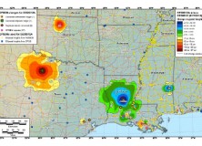
GEOID12 Error Analysis Complete and GEOID12A Model Developed
Here’s an important notice from The National Geodetic Survey (NGS) concerning the new GEOID12 model: The National Geodetic Survey has determined that the GEOID12 model was developed using erroneous input control points, primarily in the Gulf Coast region. NGS immediately corrected these errors and developed a replacement model: GEOID12A. GEOID12A is now available for public…
-

The National Geodetic Survey Improves the National Spatial Reference System with Simultaneous Major Product Releases
The National Geodetic Survey Improves the National Spatial Reference System with Simultaneous Major Product Releases In the first week of July, NOAA’s National Geodetic Survey (NGS) released the results of three major improvements to the National Spatial Reference System (NSRS). The NSRS is the consistent coordinate system that defines latitude, longitude, height, scale, gravity, and…
-

NGS Releases New Geoid Model to Serve Surveying, Engineering, and Scientific Communities
NGS Releases New Geoid Model to Serve Surveying, Engineering, and Scientific Communities In the last week, the National Geodetic Survey has released a new height transformation model for surveyors, engineers, and the scientific community involved in water flow and the determination of heights with respect to mean sea level. The new “GEOID12” model, implemented in…
-

National Geodetic Survey (NGS) New CORS Coordinates and Absolute Antenna Calibration Pages
National Geodetic Survey (NGS) Releases New CORS Coordinates and Absolute Antenna Calibration Pages NAD83(2011,MA11,PA11) epoch 2010.00 Coordinates On September 6, 2011, NGS updated the National Spatial Reference System NAD 83 (CORS96, MARP00, PACP00) positions and velocities for all CORS sites, to NAD 83 (2011, MA11, PA11). The NAD 83 (2011) frame, which is relative to the…