Your cart is currently empty!
Category: NOAA
Federal Government Shutdown Shutters NOAA NGS OPUS Website
If you use the Federal Government OPUS website operated by NGS and NOAA, then you may already have discovered that the site is non-functional and have already seen the notice in the image shown here. If you needed OPUS for your land surveying work, but did not realize that the OPUS website has been shuttered,…
NGS Announces Release of Geodetic Data from Geoid Slope Validation Survey 2011 (GSVS11)
Between February 2011 and April 2012, the National Geodetic Survey (NGS) executed one of the most comprehensive geodetic surveys in its history: the Geoid Slope Validation Survey of 2011 (GSVS11).

National Geodetic Survey (NGS) Online Map of Corbin’s New LiDAR Evaluation Site Available
Online Map of Corbin’s New LiDAR Evaluation Site Available In December, a permanent airborne Light Detection and Ranging (LiDAR) test and evaluation site was installed at the National Geodetic Survey (NGS) Instrumentation & Methodologies Branch facility located in Corbin, Virginia.

National Geodetic Survey Updates “Bluebooking” Process for GPS Projects
NGS updates “Bluebooking” process for GPS projects. Breaking news from the NOAA National Geodetic Survey (NGS) about GPS projects “Bluebooking” process:

NOAA Releases NGS Data Explorer Map Application
NOAA Releases NGS Data Explorer Map Application This week, NOAA released a new web application to allow users to view National Geodetic Survey (NGS) geodetic control across the United States and its territories using Google Maps.

NGS Enabling Historical “T-Sheets” to be Accurately and Efficiently Geo-referenced
NGS Enabling Historical “T-Sheets” to be Accurately and Efficiently Geo-referenced Historical Topographic Sheets (“T-Sheets”) produced by the U.S. Coast and Geodetic Survey are referenced to various horizontal datums in use over the two hundred years since the first Survey of the Coast in 1816. To use these maps to document coastal change, a conversion has…

GEOID12 Error Analysis Complete and GEOID12A Model Developed
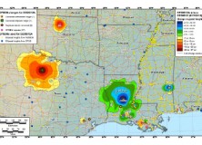
Here’s an important notice from The National Geodetic Survey (NGS) concerning the new GEOID12 model: The National Geodetic Survey has determined that the GEOID12 model was developed using erroneous input control points, primarily in the Gulf Coast region. NGS immediately corrected these errors and developed a replacement model: GEOID12A. GEOID12A is now available for public…

The National Geodetic Survey Improves the National Spatial Reference System with Simultaneous Major Product Releases
The National Geodetic Survey Improves the National Spatial Reference System with Simultaneous Major Product Releases In the first week of July, NOAA’s National Geodetic Survey (NGS) released the results of three major improvements to the National Spatial Reference System (NSRS). The NSRS is the consistent coordinate system that defines latitude, longitude, height, scale, gravity, and…

NGS Releases New Geoid Model to Serve Surveying, Engineering, and Scientific Communities
NGS Releases New Geoid Model to Serve Surveying, Engineering, and Scientific Communities In the last week, the National Geodetic Survey has released a new height transformation model for surveyors, engineers, and the scientific community involved in water flow and the determination of heights with respect to mean sea level. The new “GEOID12” model, implemented in…

NGS Developing GIS Tools and Datasets for Display and Analysis of Survey Data
NGS Developing GIS Tools and Datasets for Display and Analysis of Survey Data NOAA’s National Geodetic Survey (NGS) is in the process of developing new Geographic Information System (GIS) software tools for display and analysis of NGS survey data.

Professional Land Surveyor Weekly Roundup September 25, 2011
Updates & Upgrades In this week’s Professional Land Surveyor Weekly Roundup, I want to explain a few site upgrades in addition to this week’s summary. If you are a regular visitor here, you’ve no doubt noticed a new look. You also might have found some of the site features updated, too. What’s happening, simply is…
NOAA Office of Coast Survey Charts to Provide More Info Faster
Revolutionary Change in NOAA Nautical Chart Production Means More Products, Faster, for Maritime Use NOAA’s development of a new navigational chart processing system, designed to meet the changing needs of the maritime community, moves into initial limited production on September 21. The new system, which slims down the current map production process while it beefs…
NOAA’s VDatum a Free Unlimited Access Web-Based GIS Software Tool
NOAA Vertical Datum Transformation tool NOAA’s just-completed first edition VDatum tool will allow users to combine and transform geospatial data from different sources onto a single vertical reference surface, removing the largest obstacle GIS users face when creating products that enable safe navigation and serve other vital purposes for coastal communities. The Vertical Datum Transformation tool, known…