Category: NGS
-

National Geodetic Survey (NGS) Online Map of Corbin’s New LiDAR Evaluation Site Available
Online Map of Corbin’s New LiDAR Evaluation Site Available In December, a permanent airborne Light Detection and Ranging (LiDAR) test and evaluation site was installed at the National Geodetic Survey (NGS) Instrumentation & Methodologies Branch facility located in Corbin, Virginia.
-
National Geodetic Survey Updates “Bluebooking” Process for GPS Projects
NGS updates “Bluebooking” process for GPS projects. Breaking news from the NOAA National Geodetic Survey (NGS) about GPS projects “Bluebooking” process:
-

NOAA Releases NGS Data Explorer Map Application
NOAA Releases NGS Data Explorer Map Application This week, NOAA released a new web application to allow users to view National Geodetic Survey (NGS) geodetic control across the United States and its territories using Google Maps.
-
NGS Enabling Historical “T-Sheets” to be Accurately and Efficiently Geo-referenced
NGS Enabling Historical “T-Sheets” to be Accurately and Efficiently Geo-referenced Historical Topographic Sheets (“T-Sheets”) produced by the U.S. Coast and Geodetic Survey are referenced to various horizontal datums in use over the two hundred years since the first Survey of the Coast in 1816. To use these maps to document coastal change, a conversion has…
-
GEOID12 Error Analysis Complete and GEOID12A Model Developed
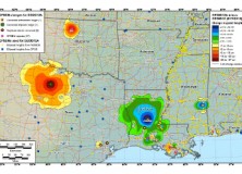
Here’s an important notice from The National Geodetic Survey (NGS) concerning the new GEOID12 model: The National Geodetic Survey has determined that the GEOID12 model was developed using erroneous input control points, primarily in the Gulf Coast region. NGS immediately corrected these errors and developed a replacement model: GEOID12A. GEOID12A is now available for public…
-
The National Geodetic Survey Improves the National Spatial Reference System with Simultaneous Major Product Releases
The National Geodetic Survey Improves the National Spatial Reference System with Simultaneous Major Product Releases In the first week of July, NOAA’s National Geodetic Survey (NGS) released the results of three major improvements to the National Spatial Reference System (NSRS). The NSRS is the consistent coordinate system that defines latitude, longitude, height, scale, gravity, and…
-

NGS Releases New Geoid Model to Serve Surveying, Engineering, and Scientific Communities
NGS Releases New Geoid Model to Serve Surveying, Engineering, and Scientific Communities In the last week, the National Geodetic Survey has released a new height transformation model for surveyors, engineers, and the scientific community involved in water flow and the determination of heights with respect to mean sea level. The new “GEOID12” model, implemented in…
-

Professional Land Surveyor Weekly Roundup January 29, 2012
Professional Land Surveyor Weekly Roundup: Create Survey Point Groups in AutoCAD Civil 3D Survey Databases Video NGS Developing GIS Tools and Datasets for Display and Analysis of Survey Data Carlson Software’s New Supervisor+GPS Tablet – aka The SuperG Video Professional Land Surveyor Weekly Roundup January 22, 2012 AutoCAD Civil 3D Set Survey Databases Working Folder…
-
NGS Developing GIS Tools and Datasets for Display and Analysis of Survey Data
NGS Developing GIS Tools and Datasets for Display and Analysis of Survey Data NOAA’s National Geodetic Survey (NGS) is in the process of developing new Geographic Information System (GIS) software tools for display and analysis of NGS survey data.