Your cart is currently empty!
Year: 2012
-

Professional Land Surveyor Weekly Roundup January 15, 2012
Professional Land Surveyor Weekly Roundup: Professional Land Surveyor Archive – Last 3 weeks:
-

LightSquared Lets Loose Lowly Yowl of Government Bias, Collusion, and Conspiracy Theories
LightSquared Lets Loose Lowly Yowl of Government Bias, Collusion, and Conspiracy Theories Today, LightSquared latest a press release, Government Committee’s Refusal to Continue Testing Highlights Systemic Pattern of Bias and Collusion, decries its perceived treatment by the Federal Government, particularly by the National Executive Committee (EXCOM) and Advisory Board for the Space-based Positioning, Navigation and Timing (PNT).…
-
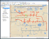
New Century Software Releases Geometric Network Synchronizer
Operators using PODS gathering systems & complex transmission pipeline systems can now automatically keep multiple geometric networks synchronized Fort Collins, CO. January 11, 2011. New Century Software (http://www.newcenturysoftware.com) announces the release of its new product, Geometric Network Synchronizer. Geometric Network Synchronizer is both an Esri ArcMap extension and a server component that builds and maintains…
-

Paul R. LeBaron, PLS, Promoted to Director of Land Surveying
Paul R. LeBaron, PLS, Promoted to Director of Land Surveying January 6, 2012: Nitsch Engineering is pleased to announce that Paul R. LeBaron, PLS, has been named Director of Land Surveying at Nitsch Engineering, taking over the position from his father, Paul S. LeBaron. With the firm for 10 years, Paul R. is a registered…
-
Esri ELA Supports Maryland’s Nationally Recognized GIS Program
ArcGIS Software Empowers Agencies to Deliver Transparency and Accountability January 4, 2012 Redlands, California—The State of Maryland has acquired an Esri enterprise license agreement (ELA) that provides unlimited access to ArcGIS software to staff in its agencies. Under Governor Martin O’Malley’s leadership, the state uses GIS for much of its work including groundbreaking transparency and…